You are here: Home > Network List > TA - USArray Transportable Network (new EarthScope stations) Stations List
> Station H24K Noodor Dome, AK, USA > Earthquake Result Viewer
H24K Noodor Dome, AK, USA - Earthquake Result Viewer
| Earthquake location: |
Near Coast Of Nicaragua |
| Earthquake latitude/longitude: |
12.8/-87.0 |
| Earthquake time(UTC): |
2016/06/10 (162) 03:25:22 GMT |
| Earthquake Depth: |
10 km |
| Earthquake Magnitude: |
6.1 MWP |
| Earthquake Catalog/Contributor: |
NEIC PDE/NEIC COMCAT |
|
| Network: |
TA USArray Transportable Network (new EarthScope stations) |
| Station: |
H24K Noodor Dome, AK, USA |
| Lat/Lon: |
65.84 N/147.88 W |
| Elevation: |
814 m |
|
| Distance: |
66.6 deg |
| Az: |
336.941 deg |
| Baz: |
111.865 deg |
| Ray Param: |
0.057491116 |
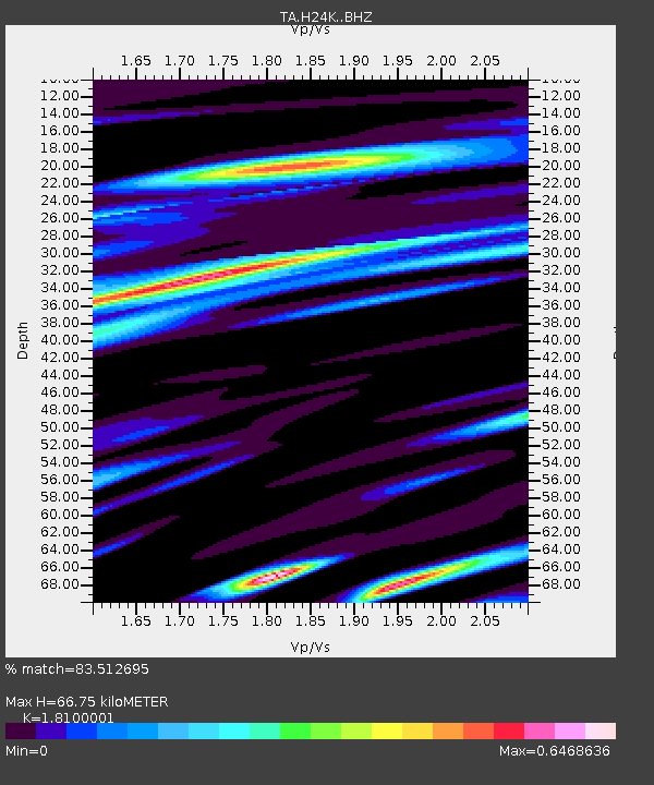
| Estimated Moho Depth: |
66.75 km |
| Estimated Crust Vp/Vs: |
1.81 |
| Assumed Crust Vp: |
6.566 km/s |
| Estimated Crust Vs: |
3.628 km/s |
| Estimated Crust Poisson's Ratio: |
0.28 |
|
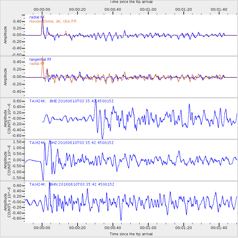
| Radial Match: |
83.512695 % |
| Radial Bump: |
387 |
| Transverse Match: |
76.23459 % |
| Transverse Bump: |
400 |
| SOD ConfigId: |
7422571 |
| Insert Time: |
2019-04-22 19:38:35.539 +0000 |
| GWidth: |
2.5 |
| Max Bumps: |
400 |
| Tol: |
0.001 |
|
Signal To Noise
| Channel | StoN | STA | LTA |
| TA:H24K: :BHZ:20160610T03:35:42.450015Z | 12.064122 | 1.0279614E-6 | 8.5208136E-8 |
| TA:H24K: :BHN:20160610T03:35:42.450015Z | 5.6663737 | 2.681651E-7 | 4.7325702E-8 |
| TA:H24K: :BHE:20160610T03:35:42.450015Z | 6.231906 | 3.9906078E-7 | 6.403511E-8 |
| Arrivals |
| Ps | 8.6 SECOND |
| PpPs | 27 SECOND |
| PsPs/PpSs | 36 SECOND |


