You are here: Home > Network List > TA - USArray Transportable Network (new EarthScope stations) Stations List
> Station J01E Myrtle Point, OR, USA > Earthquake Result Viewer
J01E Myrtle Point, OR, USA - Earthquake Result Viewer
*The percent match for this event was below the threshold and hence no stack was calculated.
| Earthquake location: |
Near Coast Of Nicaragua |
| Earthquake latitude/longitude: |
12.8/-87.0 |
| Earthquake time(UTC): |
2016/06/10 (162) 03:25:22 GMT |
| Earthquake Depth: |
10 km |
| Earthquake Magnitude: |
6.1 MWP |
| Earthquake Catalog/Contributor: |
NEIC PDE/NEIC COMCAT |
|
| Network: |
TA USArray Transportable Network (new EarthScope stations) |
| Station: |
J01E Myrtle Point, OR, USA |
| Lat/Lon: |
43.16 N/123.93 W |
| Elevation: |
128 m |
|
| Distance: |
43.9 deg |
| Az: |
320.627 deg |
| Baz: |
122.268 deg |
| Ray Param: |
$rayparam |
*The percent match for this event was below the threshold and hence was not used in the summary stack. |
|
| Radial Match: |
73.988884 % |
| Radial Bump: |
400 |
| Transverse Match: |
63.77373 % |
| Transverse Bump: |
400 |
| SOD ConfigId: |
7422571 |
| Insert Time: |
2019-04-22 19:38:44.196 +0000 |
| GWidth: |
2.5 |
| Max Bumps: |
400 |
| Tol: |
0.001 |
|
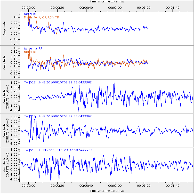
Signal To Noise
| Channel | StoN | STA | LTA |
| TA:J01E: :HHZ:20160610T03:32:58.649996Z | 11.203216 | 1.9236115E-6 | 1.7170171E-7 |
| TA:J01E: :HHN:20160610T03:32:58.649996Z | 1.7966036 | 3.6299016E-7 | 2.0204244E-7 |
| TA:J01E: :HHE:20160610T03:32:58.649996Z | 3.8801987 | 5.74307E-7 | 1.480097E-7 |
| Arrivals |
| Ps | |
| PpPs | |
| PsPs/PpSs | |


