You are here: Home > Network List > TA - USArray Transportable Network (new EarthScope stations) Stations List
> Station S22A 4UR Ranch, Creede, CO, USA > Earthquake Result Viewer
S22A 4UR Ranch, Creede, CO, USA - Earthquake Result Viewer
| Earthquake location: |
Near Coast Of Nicaragua |
| Earthquake latitude/longitude: |
12.8/-87.0 |
| Earthquake time(UTC): |
2016/06/10 (162) 03:25:22 GMT |
| Earthquake Depth: |
10 km |
| Earthquake Magnitude: |
6.1 MWP |
| Earthquake Catalog/Contributor: |
NEIC PDE/NEIC COMCAT |
|
| Network: |
TA USArray Transportable Network (new EarthScope stations) |
| Station: |
S22A 4UR Ranch, Creede, CO, USA |
| Lat/Lon: |
37.75 N/106.83 W |
| Elevation: |
2626 m |
|
| Distance: |
30.5 deg |
| Az: |
327.987 deg |
| Baz: |
139.291 deg |
| Ray Param: |
0.0793262 |
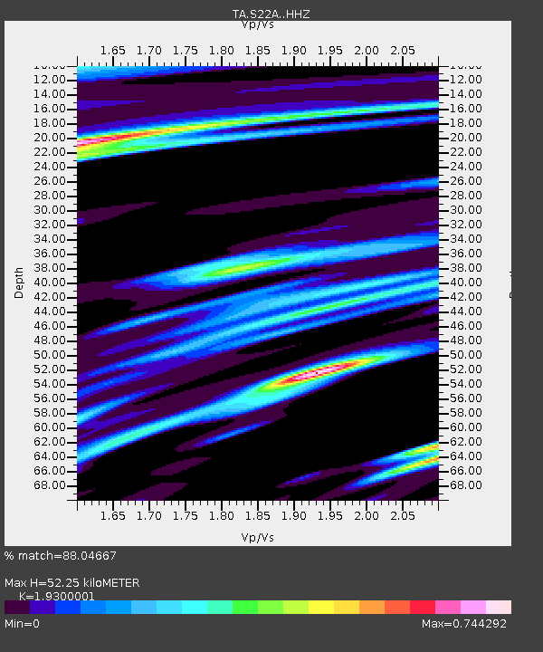
| Estimated Moho Depth: |
52.25 km |
| Estimated Crust Vp/Vs: |
1.93 |
| Assumed Crust Vp: |
6.159 km/s |
| Estimated Crust Vs: |
3.191 km/s |
| Estimated Crust Poisson's Ratio: |
0.32 |
|
| Radial Match: |
88.04667 % |
| Radial Bump: |
341 |
| Transverse Match: |
47.62559 % |
| Transverse Bump: |
355 |
| SOD ConfigId: |
7422571 |
| Insert Time: |
2019-04-22 19:39:28.977 +0000 |
| GWidth: |
2.5 |
| Max Bumps: |
400 |
| Tol: |
0.001 |
|
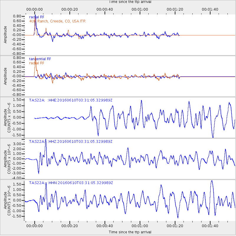
Signal To Noise
| Channel | StoN | STA | LTA |
| TA:S22A: :HHZ:20160610T03:31:05.329989Z | 18.354307 | 1.0751326E-6 | 5.8576582E-8 |
| TA:S22A: :HHN:20160610T03:31:05.329989Z | 4.86319 | 4.0253212E-7 | 8.277121E-8 |
| TA:S22A: :HHE:20160610T03:31:05.329989Z | 7.1594167 | 3.5035725E-7 | 4.8936563E-8 |
| Arrivals |
| Ps | 8.4 SECOND |
| PpPs | 23 SECOND |
| PsPs/PpSs | 32 SECOND |


