You are here: Home > Network List > UW - Pacific Northwest Regional Seismic Network Stations List
> Station LCCR Mulino, OR, USA > Earthquake Result Viewer
LCCR Mulino, OR, USA - Earthquake Result Viewer
*The percent match for this event was below the threshold and hence no stack was calculated.
| Earthquake location: |
Near Coast Of Nicaragua |
| Earthquake latitude/longitude: |
12.8/-87.0 |
| Earthquake time(UTC): |
2016/06/10 (162) 03:25:22 GMT |
| Earthquake Depth: |
10 km |
| Earthquake Magnitude: |
6.1 MWP |
| Earthquake Catalog/Contributor: |
NEIC PDE/NEIC COMCAT |
|
| Network: |
UW Pacific Northwest Regional Seismic Network |
| Station: |
LCCR Mulino, OR, USA |
| Lat/Lon: |
45.21 N/122.48 W |
| Elevation: |
273 m |
|
| Distance: |
44.1 deg |
| Az: |
323.908 deg |
| Baz: |
125.639 deg |
| Ray Param: |
$rayparam |
*The percent match for this event was below the threshold and hence was not used in the summary stack. |
|
| Radial Match: |
75.58219 % |
| Radial Bump: |
400 |
| Transverse Match: |
75.453255 % |
| Transverse Bump: |
400 |
| SOD ConfigId: |
7422571 |
| Insert Time: |
2019-04-22 19:40:03.884 +0000 |
| GWidth: |
2.5 |
| Max Bumps: |
400 |
| Tol: |
0.001 |
|
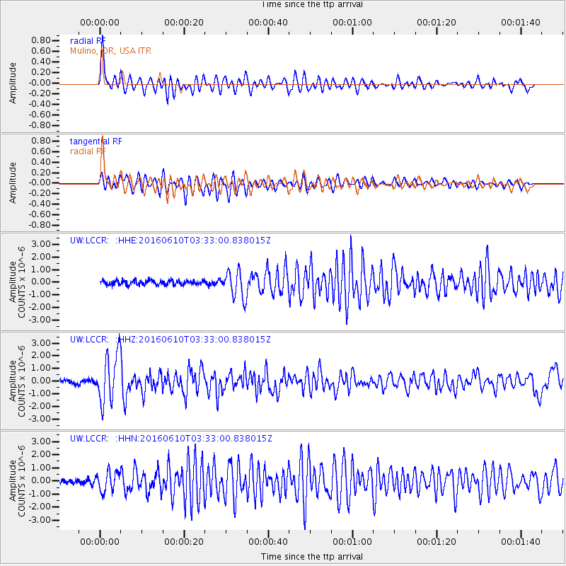
Signal To Noise
| Channel | StoN | STA | LTA |
| UW:LCCR: :HHZ:20160610T03:33:00.838015Z | 14.562611 | 1.974864E-6 | 1.3561196E-7 |
| UW:LCCR: :HHN:20160610T03:33:00.838015Z | 4.165691 | 7.457624E-7 | 1.790249E-7 |
| UW:LCCR: :HHE:20160610T03:33:00.838015Z | 5.8215265 | 1.0138343E-6 | 1.7415265E-7 |
| Arrivals |
| Ps | |
| PpPs | |
| PsPs/PpSs | |


