You are here: Home > Network List > UW - Pacific Northwest Regional Seismic Network Stations List
> Station PASS Maple Falls, WA, USA > Earthquake Result Viewer
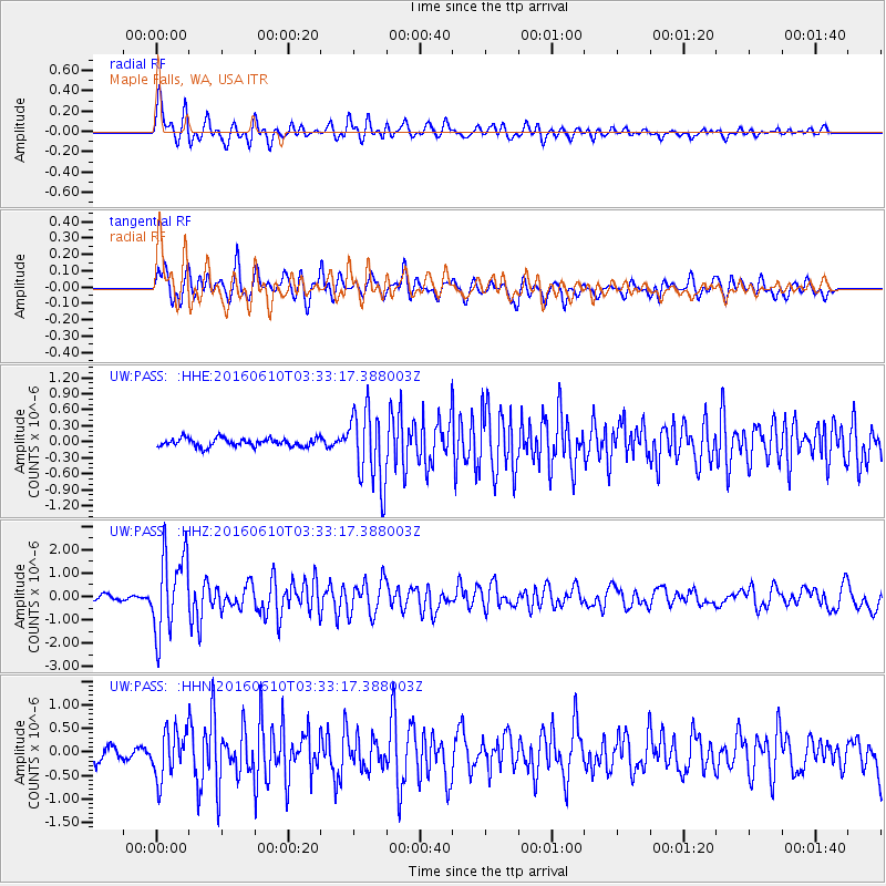
PASS Maple Falls, WA, USA - Earthquake Result Viewer
*The percent match for this event was below the threshold and hence no stack was calculated.
| Earthquake location: |
Near Coast Of Nicaragua |
| Earthquake latitude/longitude: |
12.8/-87.0 |
| Earthquake time(UTC): |
2016/06/10 (162) 03:25:22 GMT |
| Earthquake Depth: |
10 km |
| Earthquake Magnitude: |
6.1 MWP |
| Earthquake Catalog/Contributor: |
NEIC PDE/NEIC COMCAT |
|
| Network: |
UW Pacific Northwest Regional Seismic Network |
| Station: |
PASS Maple Falls, WA, USA |
| Lat/Lon: |
49.00 N/122.09 W |
| Elevation: |
174 m |
|
| Distance: |
46.2 deg |
| Az: |
328.39 deg |
| Baz: |
129.087 deg |
| Ray Param: |
$rayparam |
*The percent match for this event was below the threshold and hence was not used in the summary stack. |
|
| Radial Match: |
73.43825 % |
| Radial Bump: |
400 |
| Transverse Match: |
74.15371 % |
| Transverse Bump: |
400 |
| SOD ConfigId: |
7422571 |
| Insert Time: |
2019-04-22 19:40:08.685 +0000 |
| GWidth: |
2.5 |
| Max Bumps: |
400 |
| Tol: |
0.001 |
|
Signal To Noise
| Channel | StoN | STA | LTA |
| UW:PASS: :HHZ:20160610T03:33:17.388003Z | 17.939383 | 1.7040198E-6 | 9.4987655E-8 |
| UW:PASS: :HHN:20160610T03:33:17.388003Z | 4.897567 | 5.0678847E-7 | 1.034776E-7 |
| UW:PASS: :HHE:20160610T03:33:17.388003Z | 8.862236 | 6.6425514E-7 | 7.495345E-8 |
| Arrivals |
| Ps | |
| PpPs | |
| PsPs/PpSs | |


