You are here: Home > Network List > US - United States National Seismic Network Stations List
> Station BOZ Bozeman, Montana, USA > Earthquake Result Viewer
BOZ Bozeman, Montana, USA - Earthquake Result Viewer

| Earthquake location: |
Fiji Islands Region |
| Earthquake latitude/longitude: |
-17.6/-178.7 |
| Earthquake time(UTC): |
2000/01/13 (013) 20:07:14 GMT |
| Earthquake Depth: |
535 km |
| Earthquake Magnitude: |
5.4 MB, 6.2 MW, 6.2 MW |
| Earthquake Catalog/Contributor: |
WHDF/NEIC |
|
| Network: |
US United States National Seismic Network |
| Station: |
BOZ Bozeman, Montana, USA |
| Lat/Lon: |
45.65 N/111.63 W |
| Elevation: |
1589 m |
|
| Distance: |
87.4 deg |
| Az: |
40.31 deg |
| Baz: |
241.589 deg |
| Ray Param: |
0.04188621 |
| Estimated Moho Depth: |
60.5 km |
| Estimated Crust Vp/Vs: |
2.00 |
| Assumed Crust Vp: |
6.35 km/s |
| Estimated Crust Vs: |
3.179 km/s |
| Estimated Crust Poisson's Ratio: |
0.33 |
|
| Radial Match: |
99.73252 % |
| Radial Bump: |
18 |
| Transverse Match: |
99.96434 % |
| Transverse Bump: |
4 |
| SOD ConfigId: |
110177 |
| Insert Time: |
2010-03-05 04:28:36.193 +0000 |
| GWidth: |
2.5 |
| Max Bumps: |
400 |
| Tol: |
0.001 |
|
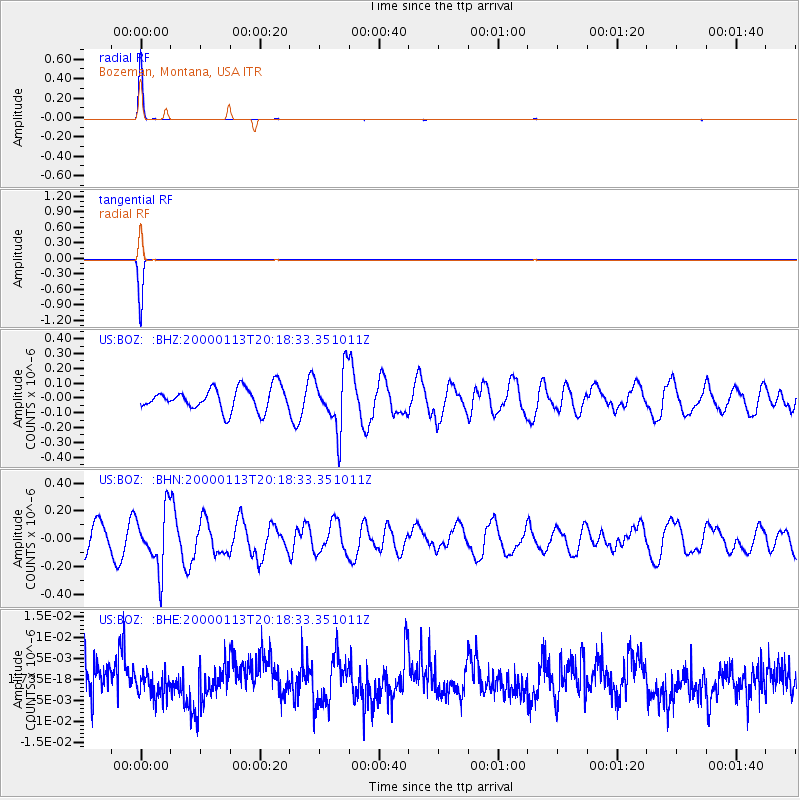
Signal To Noise
| Channel | StoN | STA | LTA |
| US:BOZ: :BHN:20000113T20:18:33.351011Z | 2.59026 | 2.0790749E-7 | 8.02651E-8 |
| US:BOZ: :BHE:20000113T20:18:33.351011Z | 0.70198137 | 2.7315794E-9 | 3.891242E-9 |
| US:BOZ: :BHZ:20000113T20:18:33.351011Z | 2.5833282 | 1.9476867E-7 | 7.5394475E-8 |
| Arrivals |
| Ps | 9.7 SECOND |
| PpPs | 28 SECOND |
| PsPs/PpSs | 38 SECOND |


