You are here: Home > Network List > US - United States National Seismic Network Stations List
> Station BOZ Bozeman, Montana, USA > Earthquake Result Viewer
BOZ Bozeman, Montana, USA - Earthquake Result Viewer
| Earthquake location: |
Fiji Islands Region |
| Earthquake latitude/longitude: |
-14.5/-177.6 |
| Earthquake time(UTC): |
2000/01/17 (017) 21:18:04 GMT |
| Earthquake Depth: |
33 km |
| Earthquake Magnitude: |
5.6 MB, 5.7 MS, 5.9 MW, 5.8 MW |
| Earthquake Catalog/Contributor: |
WHDF/NEIC |
|
| Network: |
US United States National Seismic Network |
| Station: |
BOZ Bozeman, Montana, USA |
| Lat/Lon: |
45.65 N/111.63 W |
| Elevation: |
1589 m |
|
| Distance: |
84.3 deg |
| Az: |
40.079 deg |
| Baz: |
242.738 deg |
| Ray Param: |
0.045534402 |
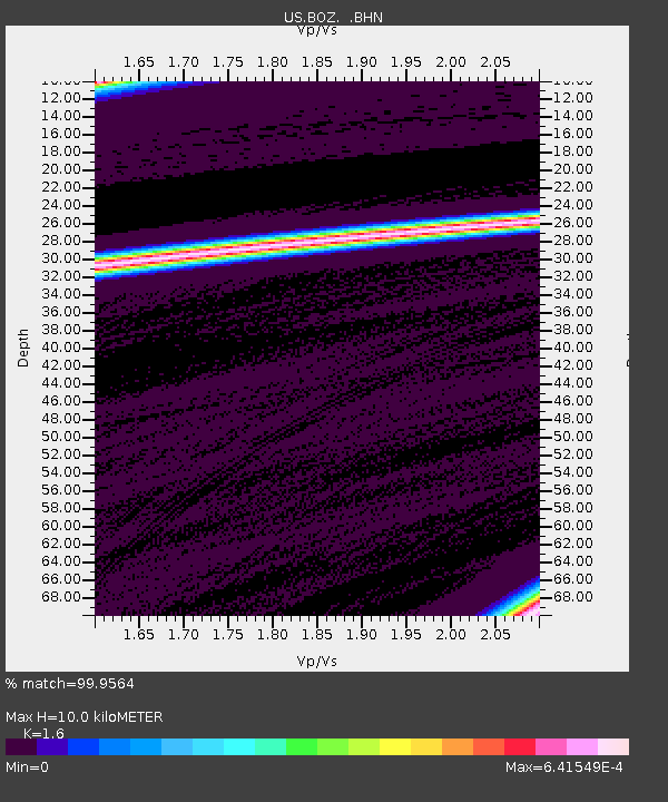
| Estimated Moho Depth: |
10.0 km |
| Estimated Crust Vp/Vs: |
1.60 |
| Assumed Crust Vp: |
6.35 km/s |
| Estimated Crust Vs: |
3.969 km/s |
| Estimated Crust Poisson's Ratio: |
0.18 |
|
| Radial Match: |
99.9564 % |
| Radial Bump: |
3 |
| Transverse Match: |
99.99537 % |
| Transverse Bump: |
2 |
| SOD ConfigId: |
110177 |
| Insert Time: |
2010-03-05 04:28:37.261 +0000 |
| GWidth: |
2.5 |
| Max Bumps: |
400 |
| Tol: |
0.001 |
|

Signal To Noise
| Channel | StoN | STA | LTA |
| US:BOZ: :BHN:20000117T21:30:02.276028Z | 2.751463 | 3.4464642E-7 | 1.2525933E-7 |
| US:BOZ: :BHE:20000117T21:30:02.276028Z | 1.0318583 | 5.145486E-9 | 4.9866204E-9 |
| US:BOZ: :BHZ:20000117T21:30:02.276028Z | 2.7500293 | 3.2276571E-7 | 1.17368096E-7 |
| Arrivals |
| Ps | 1.0 SECOND |
| PpPs | 4.0 SECOND |
| PsPs/PpSs | 5.0 SECOND |


