You are here: Home > Network List > YN10 - San Jacinto Fault Zone Stations List
> Station GVAR1 GVAR1, Anza, CA, USA > Earthquake Result Viewer
GVAR1 GVAR1, Anza, CA, USA - Earthquake Result Viewer
| Earthquake location: |
Near Coast Of Nicaragua |
| Earthquake latitude/longitude: |
12.8/-87.0 |
| Earthquake time(UTC): |
2016/06/10 (162) 03:25:22 GMT |
| Earthquake Depth: |
10 km |
| Earthquake Magnitude: |
6.1 MWP |
| Earthquake Catalog/Contributor: |
NEIC PDE/NEIC COMCAT |
|
| Network: |
YN San Jacinto Fault Zone |
| Station: |
GVAR1 GVAR1, Anza, CA, USA |
| Lat/Lon: |
33.67 N/116.71 W |
| Elevation: |
1328 m |
|
| Distance: |
34.1 deg |
| Az: |
312.47 deg |
| Baz: |
120.388 deg |
| Ray Param: |
0.07792071 |
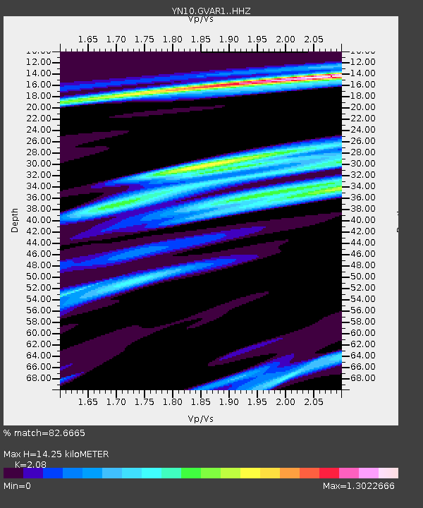
| Estimated Moho Depth: |
14.25 km |
| Estimated Crust Vp/Vs: |
2.08 |
| Assumed Crust Vp: |
6.264 km/s |
| Estimated Crust Vs: |
3.011 km/s |
| Estimated Crust Poisson's Ratio: |
0.35 |
|
| Radial Match: |
82.6665 % |
| Radial Bump: |
324 |
| Transverse Match: |
66.19584 % |
| Transverse Bump: |
400 |
| SOD ConfigId: |
7422571 |
| Insert Time: |
2019-04-22 19:41:43.516 +0000 |
| GWidth: |
2.5 |
| Max Bumps: |
400 |
| Tol: |
0.001 |
|

Signal To Noise
| Channel | StoN | STA | LTA |
| YN:GVAR1: :HHZ:20160610T03:31:36.86899Z | 6.8318033 | 5.325951E-7 | 7.7958205E-8 |
| YN:GVAR1: :HHN:20160610T03:31:36.86899Z | 3.3566496 | 1.8858029E-7 | 5.6181108E-8 |
| YN:GVAR1: :HHE:20160610T03:31:36.86899Z | 2.9397526 | 2.8113362E-7 | 9.5631734E-8 |
| Arrivals |
| Ps | 2.6 SECOND |
| PpPs | 6.6 SECOND |
| PsPs/PpSs | 9.2 SECOND |


