You are here: Home > Network List > US - United States National Seismic Network Stations List
> Station BOZ Bozeman, Montana, USA > Earthquake Result Viewer
BOZ Bozeman, Montana, USA - Earthquake Result Viewer

| Earthquake location: |
Near East Coast Of Kamchatka |
| Earthquake latitude/longitude: |
56.3/163.8 |
| Earthquake time(UTC): |
2001/08/02 (214) 23:41:06 GMT |
| Earthquake Depth: |
14 km |
| Earthquake Magnitude: |
5.9 MB, 6.2 MS, 6.3 MW, 6.2 ME |
| Earthquake Catalog/Contributor: |
WHDF/NEIC |
|
| Network: |
US United States National Seismic Network |
| Station: |
BOZ Bozeman, Montana, USA |
| Lat/Lon: |
45.65 N/111.63 W |
| Elevation: |
1589 m |
|
| Distance: |
51.1 deg |
| Az: |
63.861 deg |
| Baz: |
314.429 deg |
| Ray Param: |
0.06763543 |
| Estimated Moho Depth: |
23.5 km |
| Estimated Crust Vp/Vs: |
2.10 |
| Assumed Crust Vp: |
6.35 km/s |
| Estimated Crust Vs: |
3.027 km/s |
| Estimated Crust Poisson's Ratio: |
0.35 |
|
| Radial Match: |
95.911964 % |
| Radial Bump: |
276 |
| Transverse Match: |
71.15309 % |
| Transverse Bump: |
400 |
| SOD ConfigId: |
110165 |
| Insert Time: |
2010-03-05 04:28:56.590 +0000 |
| GWidth: |
2.5 |
| Max Bumps: |
400 |
| Tol: |
0.001 |
|
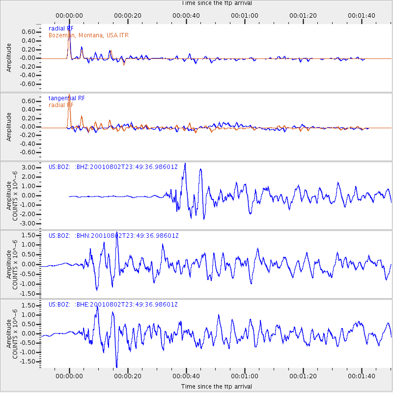
Signal To Noise
| Channel | StoN | STA | LTA |
| US:BOZ: :BHN:20010802T23:49:36.98601Z | 2.645106 | 9.121002E-8 | 3.4482557E-8 |
| US:BOZ: :BHE:20010802T23:49:36.98601Z | 3.5544338 | 1.991801E-7 | 5.6037088E-8 |
| US:BOZ: :BHZ:20010802T23:49:36.98601Z | 5.031217 | 1.9619051E-7 | 3.8994642E-8 |
| Arrivals |
| Ps | 4.3 SECOND |
| PpPs | 11 SECOND |
| PsPs/PpSs | 15 SECOND |


