You are here: Home > Network List > TA - USArray Transportable Network (new EarthScope stations) Stations List
> Station M19K Big River Lodge, Big River, AK, USA > Earthquake Result Viewer
M19K Big River Lodge, Big River, AK, USA - Earthquake Result Viewer
| Earthquake location: |
Solomon Islands |
| Earthquake latitude/longitude: |
-8.7/160.5 |
| Earthquake time(UTC): |
2016/06/10 (162) 04:17:44 GMT |
| Earthquake Depth: |
28 km |
| Earthquake Magnitude: |
6.2 MWW |
| Earthquake Catalog/Contributor: |
NEIC PDE/NEIC COMCAT |
|
| Network: |
TA USArray Transportable Network (new EarthScope stations) |
| Station: |
M19K Big River Lodge, Big River, AK, USA |
| Lat/Lon: |
61.90 N/154.39 W |
| Elevation: |
521 m |
|
| Distance: |
78.6 deg |
| Az: |
19.998 deg |
| Baz: |
225.577 deg |
| Ray Param: |
0.0495245 |
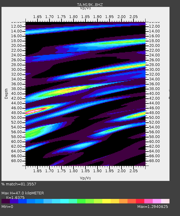
| Estimated Moho Depth: |
47.0 km |
| Estimated Crust Vp/Vs: |
1.64 |
| Assumed Crust Vp: |
6.566 km/s |
| Estimated Crust Vs: |
4.01 km/s |
| Estimated Crust Poisson's Ratio: |
0.20 |
|
| Radial Match: |
81.3557 % |
| Radial Bump: |
400 |
| Transverse Match: |
69.28419 % |
| Transverse Bump: |
400 |
| SOD ConfigId: |
7422571 |
| Insert Time: |
2019-04-22 19:46:40.420 +0000 |
| GWidth: |
2.5 |
| Max Bumps: |
400 |
| Tol: |
0.001 |
|

Signal To Noise
| Channel | StoN | STA | LTA |
| TA:M19K: :BHZ:20160610T04:29:12.099998Z | 2.720535 | 8.7128655E-7 | 3.2026293E-7 |
| TA:M19K: :BHN:20160610T04:29:12.099998Z | 0.57217693 | 1.6401223E-7 | 2.86646E-7 |
| TA:M19K: :BHE:20160610T04:29:12.099998Z | 0.6567758 | 2.8543954E-7 | 4.3460727E-7 |
| Arrivals |
| Ps | 4.7 SECOND |
| PpPs | 18 SECOND |
| PsPs/PpSs | 23 SECOND |


