You are here: Home > Network List > US - United States National Seismic Network Stations List
> Station BOZ Bozeman, Montana, USA > Earthquake Result Viewer
BOZ Bozeman, Montana, USA - Earthquake Result Viewer
| Earthquake location: |
Near East Coast Of Honshu, Japan |
| Earthquake latitude/longitude: |
38.8/141.6 |
| Earthquake time(UTC): |
2003/05/26 (146) 09:24:33 GMT |
| Earthquake Depth: |
68 km |
| Earthquake Magnitude: |
6.7 MB, 7.0 MW, 7.0 MW |
| Earthquake Catalog/Contributor: |
WHDF/NEIC |
|
| Network: |
US United States National Seismic Network |
| Station: |
BOZ Bozeman, Montana, USA |
| Lat/Lon: |
45.65 N/111.63 W |
| Elevation: |
1589 m |
|
| Distance: |
73.3 deg |
| Az: |
44.507 deg |
| Baz: |
308.71 deg |
| Ray Param: |
0.05292992 |
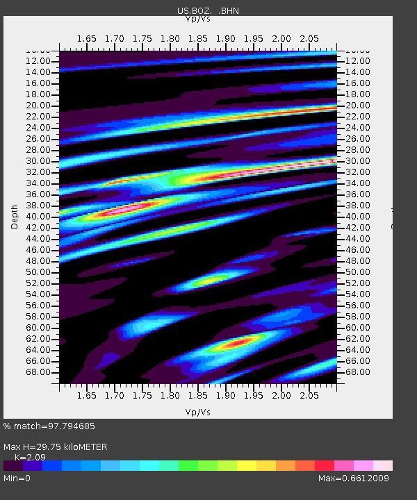
| Estimated Moho Depth: |
29.75 km |
| Estimated Crust Vp/Vs: |
2.09 |
| Assumed Crust Vp: |
6.35 km/s |
| Estimated Crust Vs: |
3.038 km/s |
| Estimated Crust Poisson's Ratio: |
0.35 |
|
| Radial Match: |
97.794685 % |
| Radial Bump: |
400 |
| Transverse Match: |
91.3776 % |
| Transverse Bump: |
400 |
| SOD ConfigId: |
110177 |
| Insert Time: |
2010-03-05 04:30:21.872 +0000 |
| GWidth: |
2.5 |
| Max Bumps: |
400 |
| Tol: |
0.001 |
|

Signal To Noise
| Channel | StoN | STA | LTA |
| US:BOZ: :BHN:20030526T09:35:26.845007Z | 10.2288 | 7.337027E-7 | 7.172911E-8 |
| US:BOZ: :BHE:20030526T09:35:26.845007Z | 15.205096 | 1.0357531E-6 | 6.8118815E-8 |
| US:BOZ: :BHZ:20030526T09:35:26.845007Z | 41.012184 | 3.054078E-6 | 7.446758E-8 |
| Arrivals |
| Ps | 5.3 SECOND |
| PpPs | 14 SECOND |
| PsPs/PpSs | 19 SECOND |


