You are here: Home > Network List > US - United States National Seismic Network Stations List
> Station BOZ Bozeman, Montana, USA > Earthquake Result Viewer
BOZ Bozeman, Montana, USA - Earthquake Result Viewer
| Earthquake location: |
Western Brazil |
| Earthquake latitude/longitude: |
-7.6/-71.7 |
| Earthquake time(UTC): |
2003/06/20 (171) 06:19:38 GMT |
| Earthquake Depth: |
558 km |
| Earthquake Magnitude: |
6.4 MB, 7.1 MW, 7.0 MW |
| Earthquake Catalog/Contributor: |
WHDF/NEIC |
|
| Network: |
US United States National Seismic Network |
| Station: |
BOZ Bozeman, Montana, USA |
| Lat/Lon: |
45.65 N/111.63 W |
| Elevation: |
1589 m |
|
| Distance: |
63.9 deg |
| Az: |
329.929 deg |
| Baz: |
134.919 deg |
| Ray Param: |
0.057185587 |
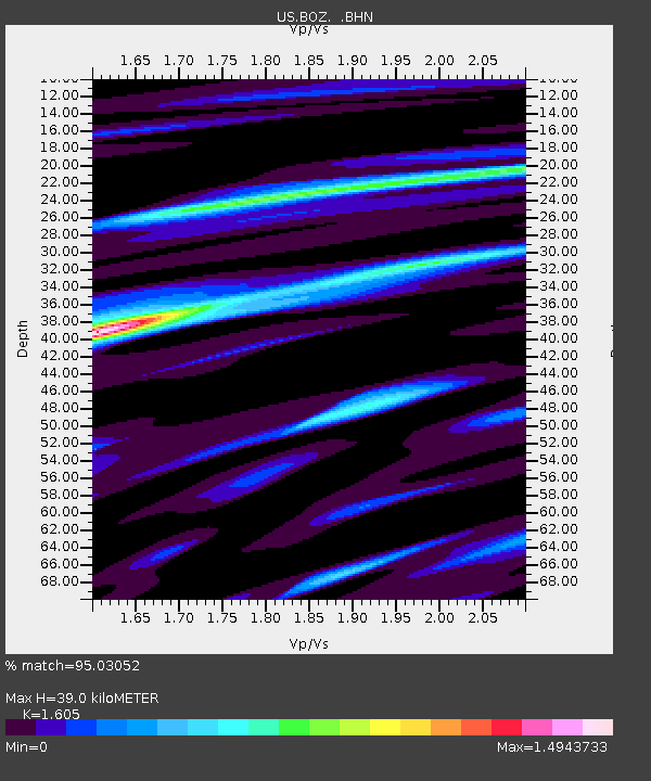
| Estimated Moho Depth: |
39.0 km |
| Estimated Crust Vp/Vs: |
1.61 |
| Assumed Crust Vp: |
6.35 km/s |
| Estimated Crust Vs: |
3.956 km/s |
| Estimated Crust Poisson's Ratio: |
0.18 |
|
| Radial Match: |
95.03052 % |
| Radial Bump: |
400 |
| Transverse Match: |
89.44142 % |
| Transverse Bump: |
400 |
| SOD ConfigId: |
110177 |
| Insert Time: |
2010-03-05 04:30:27.216 +0000 |
| GWidth: |
2.5 |
| Max Bumps: |
400 |
| Tol: |
0.001 |
|

Signal To Noise
| Channel | StoN | STA | LTA |
| US:BOZ: :BHN:20030620T06:28:46.55502Z | 36.52576 | 1.5431332E-6 | 4.2247805E-8 |
| US:BOZ: :BHE:20030620T06:28:46.55502Z | 41.929047 | 1.5027551E-6 | 3.5840433E-8 |
| US:BOZ: :BHZ:20030620T06:28:46.55502Z | 104.92788 | 5.138532E-6 | 4.8972034E-8 |
| Arrivals |
| Ps | 3.9 SECOND |
| PpPs | 15 SECOND |
| PsPs/PpSs | 19 SECOND |


