You are here: Home > Network List > US - United States National Seismic Network Stations List
> Station BOZ Bozeman, Montana, USA > Earthquake Result Viewer
BOZ Bozeman, Montana, USA - Earthquake Result Viewer

| Earthquake location: |
Eastern Honshu, Japan |
| Earthquake latitude/longitude: |
38.4/141.0 |
| Earthquake time(UTC): |
2003/07/25 (206) 22:13:29 GMT |
| Earthquake Depth: |
6.0 km |
| Earthquake Magnitude: |
6.0 MB, 5.8 MS, 6.1 MW, 5.9 MW |
| Earthquake Catalog/Contributor: |
WHDF/NEIC |
|
| Network: |
US United States National Seismic Network |
| Station: |
BOZ Bozeman, Montana, USA |
| Lat/Lon: |
45.65 N/111.63 W |
| Elevation: |
1589 m |
|
| Distance: |
74.0 deg |
| Az: |
44.156 deg |
| Baz: |
308.728 deg |
| Ray Param: |
0.052668616 |
| Estimated Moho Depth: |
29.75 km |
| Estimated Crust Vp/Vs: |
2.10 |
| Assumed Crust Vp: |
6.35 km/s |
| Estimated Crust Vs: |
3.027 km/s |
| Estimated Crust Poisson's Ratio: |
0.35 |
|
| Radial Match: |
96.09389 % |
| Radial Bump: |
400 |
| Transverse Match: |
90.5181 % |
| Transverse Bump: |
400 |
| SOD ConfigId: |
110177 |
| Insert Time: |
2010-03-05 04:30:38.450 +0000 |
| GWidth: |
2.5 |
| Max Bumps: |
400 |
| Tol: |
0.001 |
|
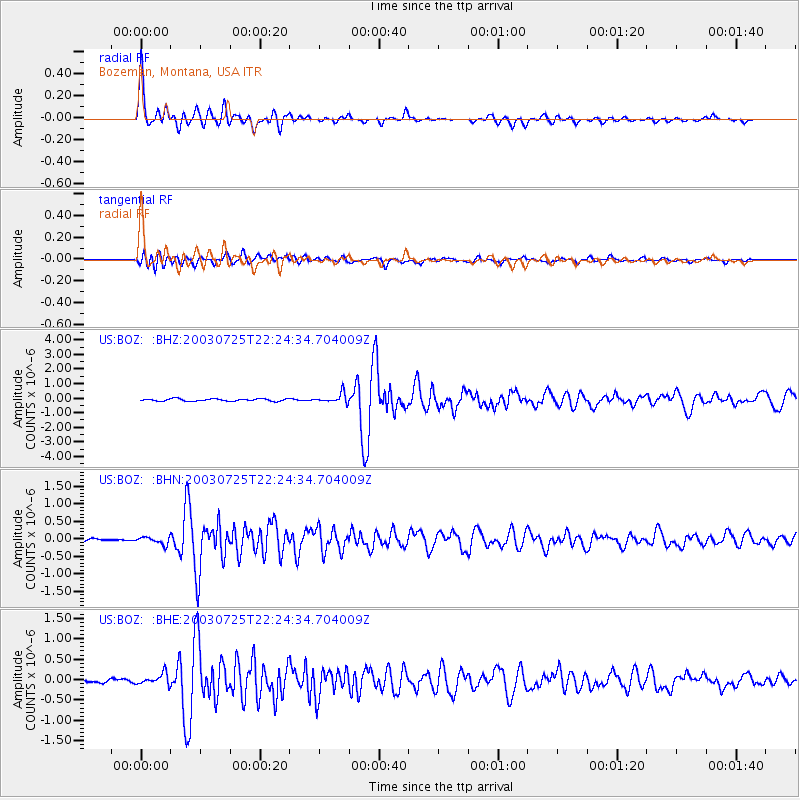
Signal To Noise
| Channel | StoN | STA | LTA |
| US:BOZ: :BHN:20030725T22:24:34.704009Z | 2.5798743 | 1.03568524E-7 | 4.0144794E-8 |
| US:BOZ: :BHE:20030725T22:24:34.704009Z | 3.760844 | 1.3751949E-7 | 3.6566124E-8 |
| US:BOZ: :BHZ:20030725T22:24:34.704009Z | 4.0952387 | 3.3652714E-7 | 8.217521E-8 |
| Arrivals |
| Ps | 5.3 SECOND |
| PpPs | 14 SECOND |
| PsPs/PpSs | 19 SECOND |


