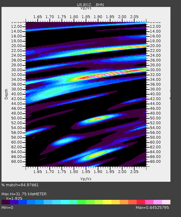
BOZ Bozeman, Montana, USA - Earthquake Result Viewer

Earthquake location: Off East Coast Of Honshu, Japan
Earthquake latitude/longitude: 37.8/142.6
Earthquake time(UTC): 2003/10/31 (304) 01:06:28 GMT
Earthquake Depth: 10 km
Earthquake Magnitude: 6.1 MB, 6.8 MS, 7.0 MW, 7.0 MW
Earthquake Catalog/Contributor: WHDF/NEIC
Network: US United States National Seismic Network
Station: BOZ Bozeman, Montana, USA
Lat/Lon: 45.65 N/111.63 W
Elevation: 1589 m
Distance: 73.5 deg
Az: 44.764 deg
Baz: 307.337 deg
Ray Param: 0.05297332
Estimated Moho Depth: 31.75 km
Estimated Crust Vp/Vs: 1.92
Assumed Crust Vp: 6.35 km/s
Estimated Crust Vs: 3.299 km/s
Estimated Crust Poisson's Ratio: 0.32
Radial Match: 94.97661 %
Radial Bump: 382
Transverse Match: 78.973076 %
Transverse Bump: 400
SOD ConfigId: 110177
Insert Time: 2010-03-05 04:30:56.392 +0000
GWidth: 2.5
Max Bumps: 400
Tol: 0.001

Signal To Noise

ChannelStoNSTALTA
US:BOZ: :BHN:20031031T01:17:29.607026Z1.24597113.1665056E-72.541396E-7
US:BOZ: :BHE:20031031T01:17:29.607026Z1.92505881.788737E-79.291857E-8
US:BOZ: :BHZ:20031031T01:17:29.607026Z2.57940394.258437E-71.6509384E-7
Arrivals
Ps4.8 SECOND
PpPs14 SECOND
PsPs/PpSs19 SECOND