You are here: Home > Network List > OX - North-East Italy Seismic Network Stations List
> Station PRED Cave del Predil > Earthquake Result Viewer
PRED Cave del Predil - Earthquake Result Viewer
| Earthquake location: |
Ascension Island Region |
| Earthquake latitude/longitude: |
-7.5/-13.6 |
| Earthquake time(UTC): |
2016/06/10 (162) 09:26:53 GMT |
| Earthquake Depth: |
10 km |
| Earthquake Magnitude: |
5.5 MWP |
| Earthquake Catalog/Contributor: |
NEIC PDE/NEIC COMCAT |
|
| Network: |
OX North-East Italy Seismic Network |
| Station: |
PRED Cave del Predil |
| Lat/Lon: |
46.44 N/13.56 E |
| Elevation: |
902 m |
|
| Distance: |
58.9 deg |
| Az: |
21.629 deg |
| Baz: |
211.91 deg |
| Ray Param: |
0.06256651 |
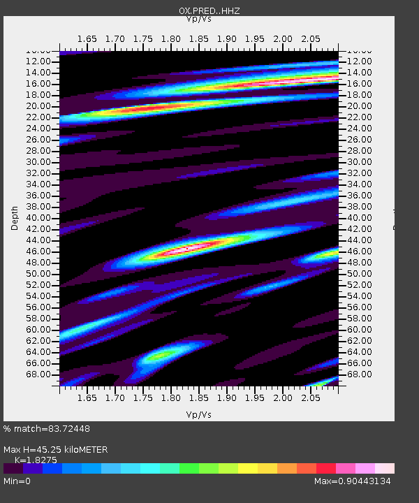
| Estimated Moho Depth: |
45.25 km |
| Estimated Crust Vp/Vs: |
1.83 |
| Assumed Crust Vp: |
6.35 km/s |
| Estimated Crust Vs: |
3.475 km/s |
| Estimated Crust Poisson's Ratio: |
0.29 |
|
| Radial Match: |
83.72448 % |
| Radial Bump: |
400 |
| Transverse Match: |
83.60258 % |
| Transverse Bump: |
400 |
| SOD ConfigId: |
7422571 |
| Insert Time: |
2019-04-22 19:55:08.385 +0000 |
| GWidth: |
2.5 |
| Max Bumps: |
400 |
| Tol: |
0.001 |
|

Signal To Noise
| Channel | StoN | STA | LTA |
| OX:PRED: :HHZ:20160610T09:36:20.847996Z | 4.132459 | 3.8602772E-7 | 9.341356E-8 |
| OX:PRED: :HHN:20160610T09:36:20.847996Z | 4.562995 | 1.5694101E-7 | 3.43943E-8 |
| OX:PRED: :HHE:20160610T09:36:20.847996Z | 1.6313477 | 8.3345924E-8 | 5.109023E-8 |
| Arrivals |
| Ps | 6.2 SECOND |
| PpPs | 19 SECOND |
| PsPs/PpSs | 25 SECOND |


