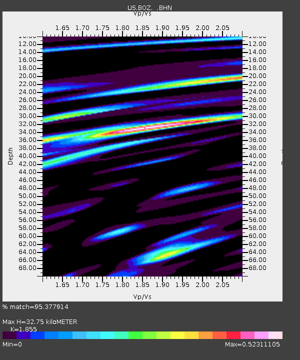
BOZ Bozeman, Montana, USA - Earthquake Result Viewer

Earthquake location: Near S. Coast Of Honshu, Japan
Earthquake latitude/longitude: 33.2/137.2
Earthquake time(UTC): 2004/09/06 (250) 23:29:35 GMT
Earthquake Depth: 10 km
Earthquake Magnitude: 6.4 MB, 6.3 MS, 6.7 MW, 6.5 MW
Earthquake Catalog/Contributor: WHDF/NEIC
Network: US United States National Seismic Network
Station: BOZ Bozeman, Montana, USA
Lat/Lon: 45.65 N/111.63 W
Elevation: 1589 m
Distance: 79.8 deg
Az: 41.657 deg
Baz: 307.401 deg
Ray Param: 0.048682597
Estimated Moho Depth: 32.75 km
Estimated Crust Vp/Vs: 1.86
Assumed Crust Vp: 6.35 km/s
Estimated Crust Vs: 3.423 km/s
Estimated Crust Poisson's Ratio: 0.30
Radial Match: 95.377914 %
Radial Bump: 400
Transverse Match: 86.72737 %
Transverse Bump: 400
SOD ConfigId: 110177
Insert Time: 2010-03-05 04:31:37.147 +0000
GWidth: 2.5
Max Bumps: 400
Tol: 0.001

Signal To Noise

ChannelStoNSTALTA
US:BOZ: :BHN:20040906T23:41:12.280002Z4.99664552.9908375E-75.985691E-8
US:BOZ: :BHE:20040906T23:41:12.280002Z12.5462033.7217725E-72.9664534E-8
US:BOZ: :BHZ:20040906T23:41:12.280002Z14.1190721.0036205E-67.108261E-8
Arrivals
Ps4.5 SECOND
PpPs14 SECOND
PsPs/PpSs19 SECOND