You are here: Home > Network List > TA - USArray Transportable Network (new EarthScope stations) Stations List
> Station MSTX Muleshoe, TX, USA > Earthquake Result Viewer
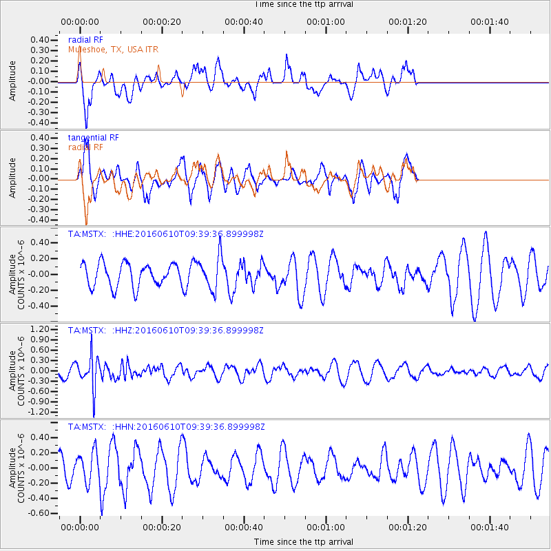
MSTX Muleshoe, TX, USA - Earthquake Result Viewer
*The percent match for this event was below the threshold and hence no stack was calculated.
| Earthquake location: |
Ascension Island Region |
| Earthquake latitude/longitude: |
-7.5/-13.6 |
| Earthquake time(UTC): |
2016/06/10 (162) 09:26:53 GMT |
| Earthquake Depth: |
10 km |
| Earthquake Magnitude: |
5.5 MWP |
| Earthquake Catalog/Contributor: |
NEIC PDE/NEIC COMCAT |
|
| Network: |
TA USArray Transportable Network (new EarthScope stations) |
| Station: |
MSTX Muleshoe, TX, USA |
| Lat/Lon: |
33.97 N/102.77 W |
| Elevation: |
1167 m |
|
| Distance: |
93.4 deg |
| Az: |
303.645 deg |
| Baz: |
96.611 deg |
| Ray Param: |
$rayparam |
*The percent match for this event was below the threshold and hence was not used in the summary stack. |
|
| Radial Match: |
54.024727 % |
| Radial Bump: |
351 |
| Transverse Match: |
65.23646 % |
| Transverse Bump: |
365 |
| SOD ConfigId: |
7422571 |
| Insert Time: |
2019-04-22 19:56:01.206 +0000 |
| GWidth: |
2.5 |
| Max Bumps: |
400 |
| Tol: |
0.001 |
|
Signal To Noise
| Channel | StoN | STA | LTA |
| TA:MSTX: :HHZ:20160610T09:39:36.899998Z | 2.6139762 | 4.6015845E-7 | 1.7603774E-7 |
| TA:MSTX: :HHN:20160610T09:39:36.899998Z | 0.9810718 | 2.1334124E-7 | 2.174573E-7 |
| TA:MSTX: :HHE:20160610T09:39:36.899998Z | 1.4871557 | 2.1826203E-7 | 1.4676475E-7 |
| Arrivals |
| Ps | |
| PpPs | |
| PsPs/PpSs | |


