You are here: Home > Network List > TA - USArray Transportable Network (new EarthScope stations) Stations List
> Station TUL1 Leonard, OK, USA > Earthquake Result Viewer
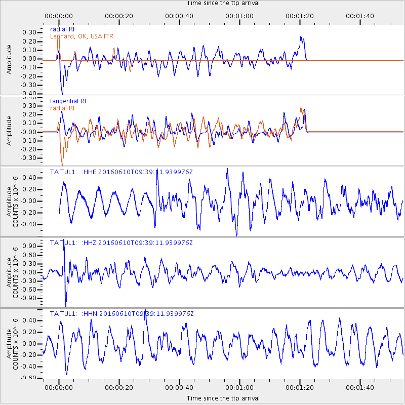
TUL1 Leonard, OK, USA - Earthquake Result Viewer
*The percent match for this event was below the threshold and hence no stack was calculated.
| Earthquake location: |
Ascension Island Region |
| Earthquake latitude/longitude: |
-7.5/-13.6 |
| Earthquake time(UTC): |
2016/06/10 (162) 09:26:53 GMT |
| Earthquake Depth: |
10 km |
| Earthquake Magnitude: |
5.5 MWP |
| Earthquake Catalog/Contributor: |
NEIC PDE/NEIC COMCAT |
|
| Network: |
TA USArray Transportable Network (new EarthScope stations) |
| Station: |
TUL1 Leonard, OK, USA |
| Lat/Lon: |
35.91 N/95.79 W |
| Elevation: |
256 m |
|
| Distance: |
88.1 deg |
| Az: |
306.412 deg |
| Baz: |
100.559 deg |
| Ray Param: |
$rayparam |
*The percent match for this event was below the threshold and hence was not used in the summary stack. |
|
| Radial Match: |
58.668484 % |
| Radial Bump: |
400 |
| Transverse Match: |
67.60481 % |
| Transverse Bump: |
400 |
| SOD ConfigId: |
7422571 |
| Insert Time: |
2019-04-22 19:56:07.995 +0000 |
| GWidth: |
2.5 |
| Max Bumps: |
400 |
| Tol: |
0.001 |
|
Signal To Noise
| Channel | StoN | STA | LTA |
| TA:TUL1: :HHZ:20160610T09:39:11.939976Z | 2.3175142 | 4.4477255E-7 | 1.9191795E-7 |
| TA:TUL1: :HHN:20160610T09:39:11.939976Z | 2.7487402 | 2.660664E-7 | 9.6795766E-8 |
| TA:TUL1: :HHE:20160610T09:39:11.939976Z | 1.2782502 | 2.0997541E-7 | 1.6426785E-7 |
| Arrivals |
| Ps | |
| PpPs | |
| PsPs/PpSs | |


