You are here: Home > Network List > TA - USArray Transportable Network (new EarthScope stations) Stations List
> Station W41B Gary Mavity, Velonia, AR, USA > Earthquake Result Viewer
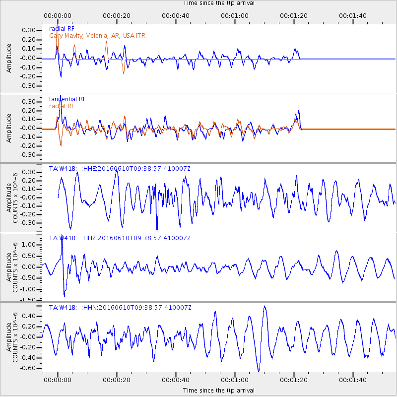
W41B Gary Mavity, Velonia, AR, USA - Earthquake Result Viewer
*The percent match for this event was below the threshold and hence no stack was calculated.
| Earthquake location: |
Ascension Island Region |
| Earthquake latitude/longitude: |
-7.5/-13.6 |
| Earthquake time(UTC): |
2016/06/10 (162) 09:26:53 GMT |
| Earthquake Depth: |
10 km |
| Earthquake Magnitude: |
5.5 MWP |
| Earthquake Catalog/Contributor: |
NEIC PDE/NEIC COMCAT |
|
| Network: |
TA USArray Transportable Network (new EarthScope stations) |
| Station: |
W41B Gary Mavity, Velonia, AR, USA |
| Lat/Lon: |
35.17 N/92.25 W |
| Elevation: |
95 m |
|
| Distance: |
85.1 deg |
| Az: |
306.272 deg |
| Baz: |
102.602 deg |
| Ray Param: |
$rayparam |
*The percent match for this event was below the threshold and hence was not used in the summary stack. |
|
| Radial Match: |
58.39374 % |
| Radial Bump: |
400 |
| Transverse Match: |
65.539955 % |
| Transverse Bump: |
327 |
| SOD ConfigId: |
7422571 |
| Insert Time: |
2019-04-22 19:56:09.114 +0000 |
| GWidth: |
2.5 |
| Max Bumps: |
400 |
| Tol: |
0.001 |
|
Signal To Noise
| Channel | StoN | STA | LTA |
| TA:W41B: :HHZ:20160610T09:38:57.410007Z | 5.597581 | 6.289214E-7 | 1.1235592E-7 |
| TA:W41B: :HHN:20160610T09:38:57.410007Z | 0.8828215 | 1.7812107E-7 | 2.0176341E-7 |
| TA:W41B: :HHE:20160610T09:38:57.410007Z | 0.7835603 | 1.3343865E-7 | 1.7029788E-7 |
| Arrivals |
| Ps | |
| PpPs | |
| PsPs/PpSs | |


