You are here: Home > Network List > TA - USArray Transportable Network (new EarthScope stations) Stations List
> Station Z41A Richland Creek Farm, El Dorado, AR, USA > Earthquake Result Viewer
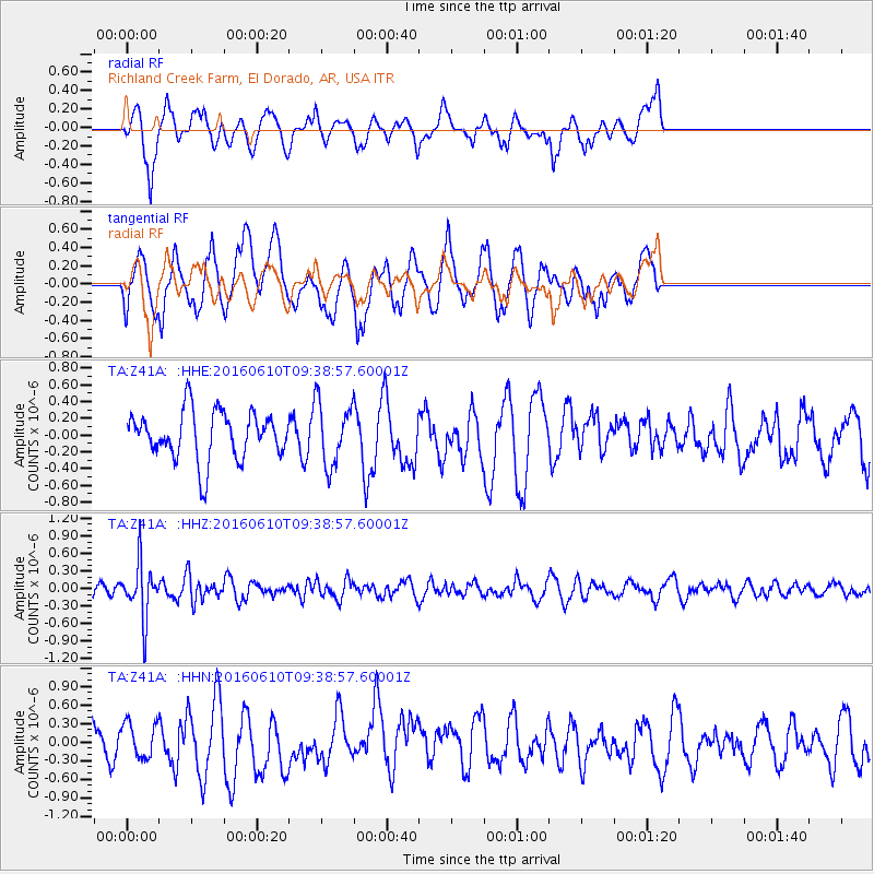
Z41A Richland Creek Farm, El Dorado, AR, USA - Earthquake Result Viewer
*The percent match for this event was below the threshold and hence no stack was calculated.
| Earthquake location: |
Ascension Island Region |
| Earthquake latitude/longitude: |
-7.5/-13.6 |
| Earthquake time(UTC): |
2016/06/10 (162) 09:26:53 GMT |
| Earthquake Depth: |
10 km |
| Earthquake Magnitude: |
5.5 MWP |
| Earthquake Catalog/Contributor: |
NEIC PDE/NEIC COMCAT |
|
| Network: |
TA USArray Transportable Network (new EarthScope stations) |
| Station: |
Z41A Richland Creek Farm, El Dorado, AR, USA |
| Lat/Lon: |
33.26 N/92.80 W |
| Elevation: |
62 m |
|
| Distance: |
85.1 deg |
| Az: |
304.299 deg |
| Baz: |
102.123 deg |
| Ray Param: |
$rayparam |
*The percent match for this event was below the threshold and hence was not used in the summary stack. |
|
| Radial Match: |
39.54127 % |
| Radial Bump: |
280 |
| Transverse Match: |
48.59658 % |
| Transverse Bump: |
400 |
| SOD ConfigId: |
7422571 |
| Insert Time: |
2019-04-22 19:56:11.946 +0000 |
| GWidth: |
2.5 |
| Max Bumps: |
400 |
| Tol: |
0.001 |
|
Signal To Noise
| Channel | StoN | STA | LTA |
| TA:Z41A: :HHZ:20160610T09:38:57.60001Z | 6.8273616 | 4.7569787E-7 | 6.967522E-8 |
| TA:Z41A: :HHN:20160610T09:38:57.60001Z | 0.93704665 | 2.880161E-7 | 3.073658E-7 |
| TA:Z41A: :HHE:20160610T09:38:57.60001Z | 1.2958046 | 3.7057745E-7 | 2.859825E-7 |
| Arrivals |
| Ps | |
| PpPs | |
| PsPs/PpSs | |


