BOZ Bozeman, Montana, USA - Earthquake Result Viewer
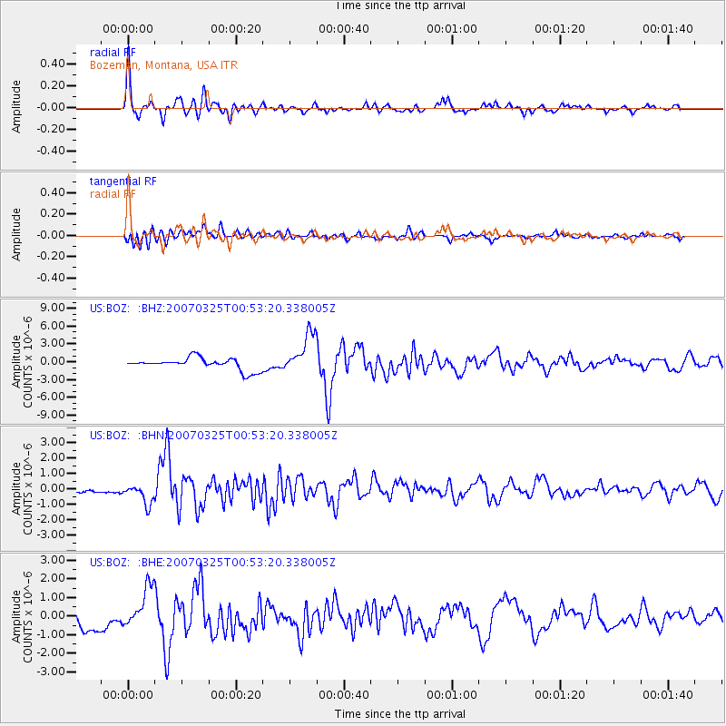
Earthquake location: Near West Coast Of Honshu, Japan
Earthquake latitude/longitude: 37.3/136.6
Earthquake time(UTC): 2007/03/25 (084) 00:41:57 GMT
Earthquake Depth: 8.0 km
Earthquake Magnitude: 6.1 MB, 6.8 MS, 6.7 MW, 6.6 MW
Earthquake Catalog/Contributor: WHDF/NEIC
Network: US United States National Seismic Network
Station: BOZ Bozeman, Montana, USA
Lat/Lon: 45.65 N/111.63 W
Elevation: 1589 m
Distance: 77.1 deg
Az: 41.929 deg
Baz: 310.602 deg
Ray Param: 0.05054153
Estimated Moho Depth: 32.5 km
Estimated Crust Vp/Vs: 1.87
Assumed Crust Vp: 6.35 km/s
Estimated Crust Vs: 3.391 km/s
Estimated Crust Poisson's Ratio: 0.30
Radial Match: 95.211845 %
Radial Bump: 400
Transverse Match: 85.29731 %
Transverse Bump: 400
SOD ConfigId: 2564
Insert Time: 2010-03-05 04:32:01.937 +0000
GWidth: 2.5
Max Bumps: 400
Tol: 0.001

Signal To Noise

ChannelStoNSTALTA
US:BOZ: :BHN:20070325T00:53:20.338005Z5.6585256.4131143E-71.1333544E-7
US:BOZ: :BHE:20070325T00:53:20.338005Z3.23454051.1428516E-63.5332735E-7
US:BOZ: :BHZ:20070325T00:53:20.338005Z3.4124453.4873844E-61.0219607E-6
Arrivals
Ps4.6 SECOND
PpPs14 SECOND
PsPs/PpSs19 SECOND