You are here: Home > Network List > UW - Pacific Northwest Regional Seismic Network Stations List
> Station MRBL Marblemount, WA, USA > Earthquake Result Viewer
MRBL Marblemount, WA, USA - Earthquake Result Viewer
*The percent match for this event was below the threshold and hence no stack was calculated.
| Earthquake location: |
Fiji Islands Region |
| Earthquake latitude/longitude: |
-16.5/-177.2 |
| Earthquake time(UTC): |
2016/06/10 (162) 18:29:50 GMT |
| Earthquake Depth: |
10 km |
| Earthquake Magnitude: |
5.7 MB, 5.5 MS_20, 5.8 MWW |
| Earthquake Catalog/Contributor: |
NEIC PDE/NEIC COMCAT |
|
| Network: |
UW Pacific Northwest Regional Seismic Network |
| Station: |
MRBL Marblemount, WA, USA |
| Lat/Lon: |
48.52 N/121.48 W |
| Elevation: |
75 m |
|
| Distance: |
81.5 deg |
| Az: |
33.763 deg |
| Baz: |
233.308 deg |
| Ray Param: |
$rayparam |
*The percent match for this event was below the threshold and hence was not used in the summary stack. |
|
| Radial Match: |
62.244015 % |
| Radial Bump: |
400 |
| Transverse Match: |
59.599968 % |
| Transverse Bump: |
400 |
| SOD ConfigId: |
7422571 |
| Insert Time: |
2019-04-22 20:03:36.010 +0000 |
| GWidth: |
2.5 |
| Max Bumps: |
400 |
| Tol: |
0.001 |
|
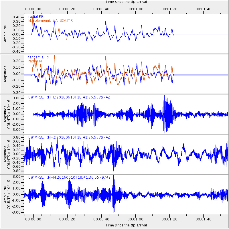
Signal To Noise
| Channel | StoN | STA | LTA |
| UW:MRBL: :HHZ:20160610T18:41:36.557974Z | 1.8133655 | 2.0940051E-7 | 1.1547618E-7 |
| UW:MRBL: :HHN:20160610T18:41:36.557974Z | 2.28303 | 5.343914E-7 | 2.3407112E-7 |
| UW:MRBL: :HHE:20160610T18:41:36.557974Z | 2.7089782 | 8.8900117E-7 | 3.2816845E-7 |
| Arrivals |
| Ps | |
| PpPs | |
| PsPs/PpSs | |


