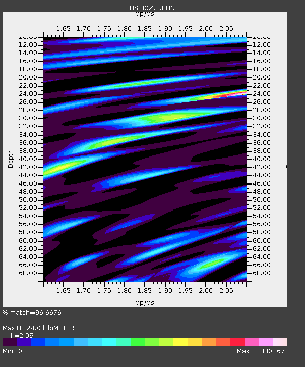
BOZ Bozeman, Montana, USA - Earthquake Result Viewer
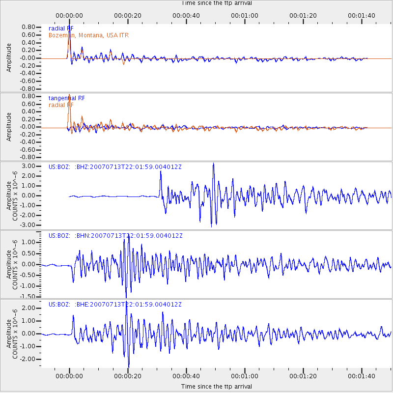
Earthquake location: Andreanof Islands, Aleutian Is.
Earthquake latitude/longitude: 51.8/-176.3
Earthquake time(UTC): 2007/07/13 (194) 21:54:43 GMT
Earthquake Depth: 35 km
Earthquake Magnitude: 5.7 MB, 5.6 MS, 6.0 MW, 5.9 MW
Earthquake Catalog/Contributor: WHDF/NEIC
Network: US United States National Seismic Network
Station: BOZ Bozeman, Montana, USA
Lat/Lon: 45.65 N/111.63 W
Elevation: 1589 m
Distance: 41.8 deg
Az: 71.944 deg
Baz: 302.761 deg
Ray Param: 0.07347629
Estimated Moho Depth: 24.0 km
Estimated Crust Vp/Vs: 2.09
Assumed Crust Vp: 6.35 km/s
Estimated Crust Vs: 3.038 km/s
Estimated Crust Poisson's Ratio: 0.35
Radial Match: 96.6676 %
Radial Bump: 347
Transverse Match: 91.38465 %
Transverse Bump: 400
SOD ConfigId: 2564
Insert Time: 2010-03-05 04:32:51.566 +0000
GWidth: 2.5
Max Bumps: 400
Tol: 0.001

Signal To Noise

ChannelStoNSTALTA
US:BOZ: :BHN:20070713T22:01:59.004012Z12.0748533.454179E-72.8606387E-8
US:BOZ: :BHE:20070713T22:01:59.004012Z14.9231285.1467015E-73.4488085E-8
US:BOZ: :BHZ:20070713T22:01:59.004012Z27.6798929.0827655E-73.281359E-8
Arrivals
Ps4.4 SECOND
PpPs11 SECOND
PsPs/PpSs15 SECOND