You are here: Home > Network List > N4 - Central and EAstern US Network Stations List
> Station V51A Loudon, TN, USA > Earthquake Result Viewer
V51A Loudon, TN, USA - Earthquake Result Viewer
| Earthquake location: |
Central East Pacific Rise |
| Earthquake latitude/longitude: |
-4.4/-104.8 |
| Earthquake time(UTC): |
2016/06/13 (165) 00:59:39 GMT |
| Earthquake Depth: |
10 km |
| Earthquake Magnitude: |
5.7 MWW, 5.6 MWB, 5.7 MWC |
| Earthquake Catalog/Contributor: |
NEIC PDE/NEIC COMCAT |
|
| Network: |
N4 Central and EAstern US Network |
| Station: |
V51A Loudon, TN, USA |
| Lat/Lon: |
35.80 N/84.35 W |
| Elevation: |
243 m |
|
| Distance: |
44.4 deg |
| Az: |
23.97 deg |
| Baz: |
209.887 deg |
| Ray Param: |
0.071951084 |
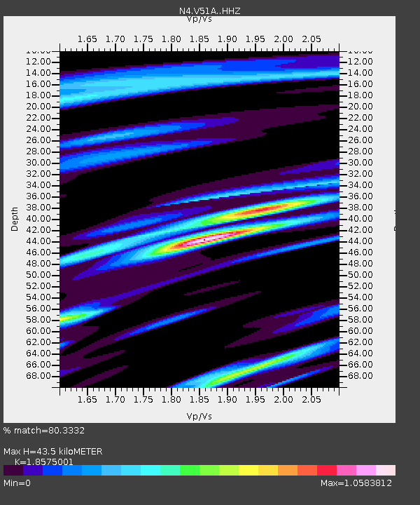
| Estimated Moho Depth: |
43.5 km |
| Estimated Crust Vp/Vs: |
1.86 |
| Assumed Crust Vp: |
6.35 km/s |
| Estimated Crust Vs: |
3.419 km/s |
| Estimated Crust Poisson's Ratio: |
0.30 |
|
| Radial Match: |
80.3332 % |
| Radial Bump: |
379 |
| Transverse Match: |
44.66639 % |
| Transverse Bump: |
400 |
| SOD ConfigId: |
7422571 |
| Insert Time: |
2019-04-22 20:11:08.632 +0000 |
| GWidth: |
2.5 |
| Max Bumps: |
400 |
| Tol: |
0.001 |
|

Signal To Noise
| Channel | StoN | STA | LTA |
| N4:V51A: :HHZ:20160613T01:07:19.520005Z | 2.6221461 | 2.1405431E-7 | 8.163325E-8 |
| N4:V51A: :HHN:20160613T01:07:19.520005Z | 1.7396574 | 1.3686045E-7 | 7.867092E-8 |
| N4:V51A: :HHE:20160613T01:07:19.520005Z | 1.0062157 | 6.316915E-8 | 6.277894E-8 |
| Arrivals |
| Ps | 6.2 SECOND |
| PpPs | 18 SECOND |
| PsPs/PpSs | 25 SECOND |


