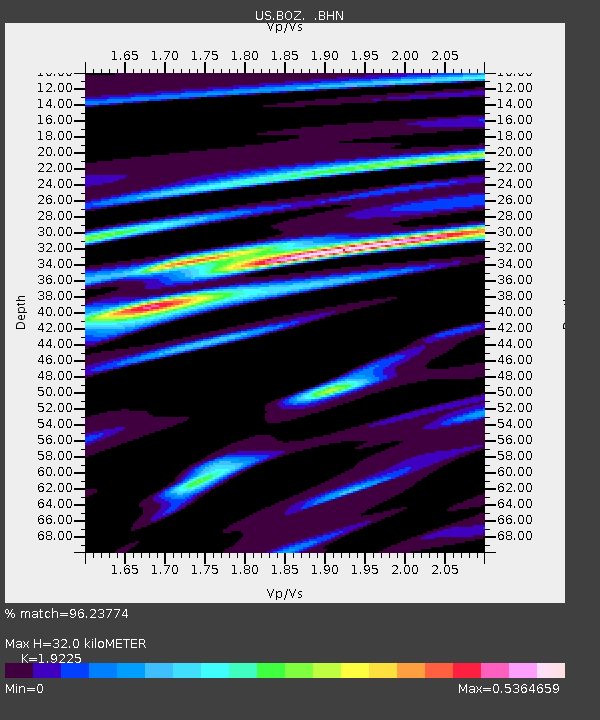
BOZ Bozeman, Montana, USA - Earthquake Result Viewer
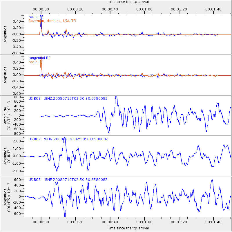
Earthquake location: Off East Coast Of Honshu, Japan
Earthquake latitude/longitude: 37.6/142.2
Earthquake time(UTC): 2008/07/19 (201) 02:39:28 GMT
Earthquake Depth: 22 km
Earthquake Magnitude: 6.2 MB, 7.0 MS, 7.0 MW, 6.9 MW
Earthquake Catalog/Contributor: WHDF/NEIC
Network: US United States National Seismic Network
Station: BOZ Bozeman, Montana, USA
Lat/Lon: 45.65 N/111.63 W
Elevation: 1589 m
Distance: 73.9 deg
Az: 44.531 deg
Baz: 307.385 deg
Ray Param: 0.05267494
Estimated Moho Depth: 32.0 km
Estimated Crust Vp/Vs: 1.92
Assumed Crust Vp: 6.35 km/s
Estimated Crust Vs: 3.303 km/s
Estimated Crust Poisson's Ratio: 0.31
Radial Match: 96.23774 %
Radial Bump: 336
Transverse Match: 81.012695 %
Transverse Bump: 400
SOD ConfigId: 2504
Insert Time: 2010-03-05 04:33:31.040 +0000
GWidth: 2.5
Max Bumps: 400
Tol: 0.001

Signal To Noise

ChannelStoNSTALTA
US:BOZ: :BHN:20080719T02:50:30.658008Z9.1267150.261835720.028688932
US:BOZ: :BHE:20080719T02:50:30.658008Z3.18365240.06858960.021544311
US:BOZ: :BHZ:20080719T02:50:30.658008Z6.18006470.109381080.017699018
Arrivals
Ps4.8 SECOND
PpPs14 SECOND
PsPs/PpSs19 SECOND