You are here: Home > Network List > TA - USArray Transportable Network (new EarthScope stations) Stations List
> Station O17K Koliganek, Bristol Bay, AK, USA > Earthquake Result Viewer
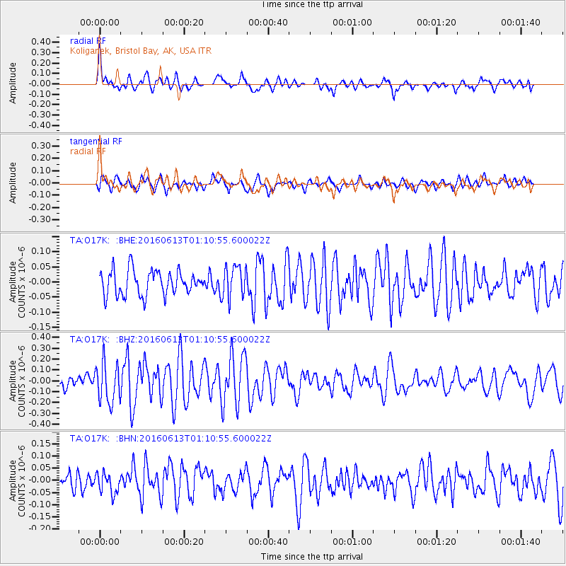
O17K Koliganek, Bristol Bay, AK, USA - Earthquake Result Viewer
*The percent match for this event was below the threshold and hence no stack was calculated.
| Earthquake location: |
Central East Pacific Rise |
| Earthquake latitude/longitude: |
-4.4/-104.8 |
| Earthquake time(UTC): |
2016/06/13 (165) 00:59:39 GMT |
| Earthquake Depth: |
10 km |
| Earthquake Magnitude: |
5.7 MWW, 5.6 MWB, 5.7 MWC |
| Earthquake Catalog/Contributor: |
NEIC PDE/NEIC COMCAT |
|
| Network: |
TA USArray Transportable Network (new EarthScope stations) |
| Station: |
O17K Koliganek, Bristol Bay, AK, USA |
| Lat/Lon: |
59.77 N/157.09 W |
| Elevation: |
156 m |
|
| Distance: |
76.0 deg |
| Az: |
335.636 deg |
| Baz: |
125.613 deg |
| Ray Param: |
$rayparam |
*The percent match for this event was below the threshold and hence was not used in the summary stack. |
|
| Radial Match: |
71.72877 % |
| Radial Bump: |
400 |
| Transverse Match: |
59.177044 % |
| Transverse Bump: |
400 |
| SOD ConfigId: |
7422571 |
| Insert Time: |
2019-04-22 20:13:36.999 +0000 |
| GWidth: |
2.5 |
| Max Bumps: |
400 |
| Tol: |
0.001 |
|
Signal To Noise
| Channel | StoN | STA | LTA |
| TA:O17K: :BHZ:20160613T01:10:55.600022Z | 3.7028773 | 1.862386E-7 | 5.0295647E-8 |
| TA:O17K: :BHN:20160613T01:10:55.600022Z | 0.9637839 | 4.2550738E-8 | 4.4149665E-8 |
| TA:O17K: :BHE:20160613T01:10:55.600022Z | 1.2968621 | 5.2504763E-8 | 4.0486004E-8 |
| Arrivals |
| Ps | |
| PpPs | |
| PsPs/PpSs | |


