You are here: Home > Network List > US - United States National Seismic Network Stations List
> Station BOZ Bozeman, Montana, USA > Earthquake Result Viewer
BOZ Bozeman, Montana, USA - Earthquake Result Viewer
| Earthquake location: |
Kuril Islands |
| Earthquake latitude/longitude: |
46.0/151.4 |
| Earthquake time(UTC): |
2009/04/18 (108) 19:17:58 GMT |
| Earthquake Depth: |
35 km |
| Earthquake Magnitude: |
6.3 MB, 6.3 MS, 6.6 MW, 6.4 MW |
| Earthquake Catalog/Contributor: |
WHDF/NEIC |
|
| Network: |
US United States National Seismic Network |
| Station: |
BOZ Bozeman, Montana, USA |
| Lat/Lon: |
45.65 N/111.63 W |
| Elevation: |
1589 m |
|
| Distance: |
63.1 deg |
| Az: |
51.319 deg |
| Baz: |
309.147 deg |
| Ray Param: |
0.059720673 |
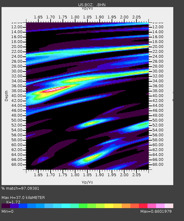
| Estimated Moho Depth: |
37.0 km |
| Estimated Crust Vp/Vs: |
1.72 |
| Assumed Crust Vp: |
6.35 km/s |
| Estimated Crust Vs: |
3.692 km/s |
| Estimated Crust Poisson's Ratio: |
0.24 |
|
| Radial Match: |
97.09381 % |
| Radial Bump: |
309 |
| Transverse Match: |
86.5036 % |
| Transverse Bump: |
400 |
| SOD ConfigId: |
2658 |
| Insert Time: |
2010-03-05 04:35:05.740 +0000 |
| GWidth: |
2.5 |
| Max Bumps: |
400 |
| Tol: |
0.001 |
|

Signal To Noise
| Channel | StoN | STA | LTA |
| US:BOZ: :BHN:20090418T19:27:52.307014Z | 22.520477 | 1.5763819E-6 | 6.999772E-8 |
| US:BOZ: :BHE:20090418T19:27:52.307014Z | 4.3122187 | 3.956863E-7 | 9.175933E-8 |
| US:BOZ: :BHZ:20090418T19:27:52.307014Z | 5.0783854 | 4.951048E-7 | 9.749256E-8 |
| Arrivals |
| Ps | 4.4 SECOND |
| PpPs | 15 SECOND |
| PsPs/PpSs | 20 SECOND |


