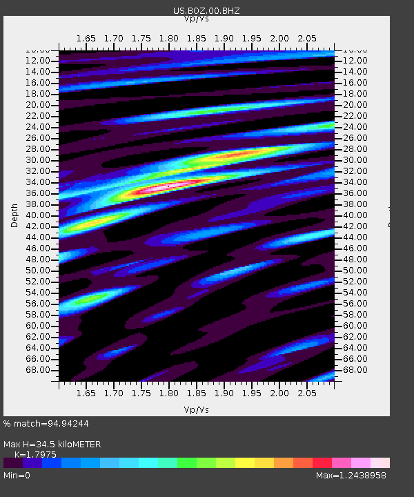
BOZ Bozeman, Montana, USA - Earthquake Result Viewer

Earthquake location: Rat Islands, Aleutian Islands
Earthquake latitude/longitude: 50.4/177.0
Earthquake time(UTC): 2009/07/06 (187) 14:53:12 GMT
Earthquake Depth: 22 km
Earthquake Magnitude: 6.0 MB, 5.8 MS, 6.1 MW, 6.0 MW
Earthquake Catalog/Contributor: WHDF/NEIC
Network: US United States National Seismic Network
Station: BOZ Bozeman, Montana, USA
Lat/Lon: 45.65 N/111.63 W
Elevation: 1589 m
Distance: 46.3 deg
Az: 66.899 deg
Baz: 303.014 deg
Ray Param: 0.07071233
Estimated Moho Depth: 34.5 km
Estimated Crust Vp/Vs: 1.80
Assumed Crust Vp: 6.35 km/s
Estimated Crust Vs: 3.533 km/s
Estimated Crust Poisson's Ratio: 0.28
Radial Match: 94.94244 %
Radial Bump: 400
Transverse Match: 82.60027 %
Transverse Bump: 400
SOD ConfigId: 2648
Insert Time: 2010-03-05 04:35:12.047 +0000
GWidth: 2.5
Max Bumps: 400
Tol: 0.001

Signal To Noise

ChannelStoNSTALTA
US:BOZ:00:BHZ:20090706T15:01:05.203013Z22.9229682.5079926E-61.094096E-7
US:BOZ:00:BHN:20090706T15:01:05.203013Z9.0378398.8247276E-79.764201E-8
US:BOZ:00:BHE:20090706T15:01:05.203013Z28.3324031.2936904E-64.566116E-8
Arrivals
Ps4.6 SECOND
PpPs14 SECOND
PsPs/PpSs19 SECOND