You are here: Home > Network List > CN - Canadian National Seismograph Network Stations List
> Station INK INUVIK, NT > Earthquake Result Viewer
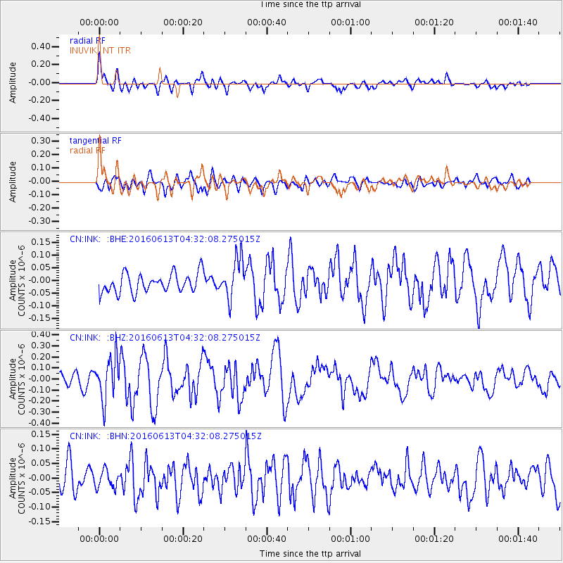
INK INUVIK, NT - Earthquake Result Viewer
*The percent match for this event was below the threshold and hence no stack was calculated.
| Earthquake location: |
Ryukyu Islands, Japan |
| Earthquake latitude/longitude: |
27.0/130.2 |
| Earthquake time(UTC): |
2016/06/13 (165) 04:21:43 GMT |
| Earthquake Depth: |
10 km |
| Earthquake Magnitude: |
5.6 MWW, 5.4 MWB, 5.6 MWC |
| Earthquake Catalog/Contributor: |
NEIC PDE/NEIC COMCAT |
|
| Network: |
CN Canadian National Seismograph Network |
| Station: |
INK INUVIK, NT |
| Lat/Lon: |
68.31 N/133.53 W |
| Elevation: |
44 m |
|
| Distance: |
67.5 deg |
| Az: |
23.584 deg |
| Baz: |
286.24 deg |
| Ray Param: |
$rayparam |
*The percent match for this event was below the threshold and hence was not used in the summary stack. |
|
| Radial Match: |
73.98176 % |
| Radial Bump: |
400 |
| Transverse Match: |
48.339794 % |
| Transverse Bump: |
400 |
| SOD ConfigId: |
7422571 |
| Insert Time: |
2019-04-22 20:20:09.252 +0000 |
| GWidth: |
2.5 |
| Max Bumps: |
400 |
| Tol: |
0.001 |
|
Signal To Noise
| Channel | StoN | STA | LTA |
| CN:INK: :BHZ:20160613T04:32:08.275015Z | 3.6496074 | 1.9008377E-7 | 5.2083347E-8 |
| CN:INK: :BHN:20160613T04:32:08.275015Z | 0.9056869 | 3.1272194E-8 | 3.4528703E-8 |
| CN:INK: :BHE:20160613T04:32:08.275015Z | 2.1465566 | 8.0996685E-8 | 3.773331E-8 |
| Arrivals |
| Ps | |
| PpPs | |
| PsPs/PpSs | |


