You are here: Home > Network List > KN - Kyrgyz Seismic Telemetry Network Stations List
> Station TKM2 - > Earthquake Result Viewer
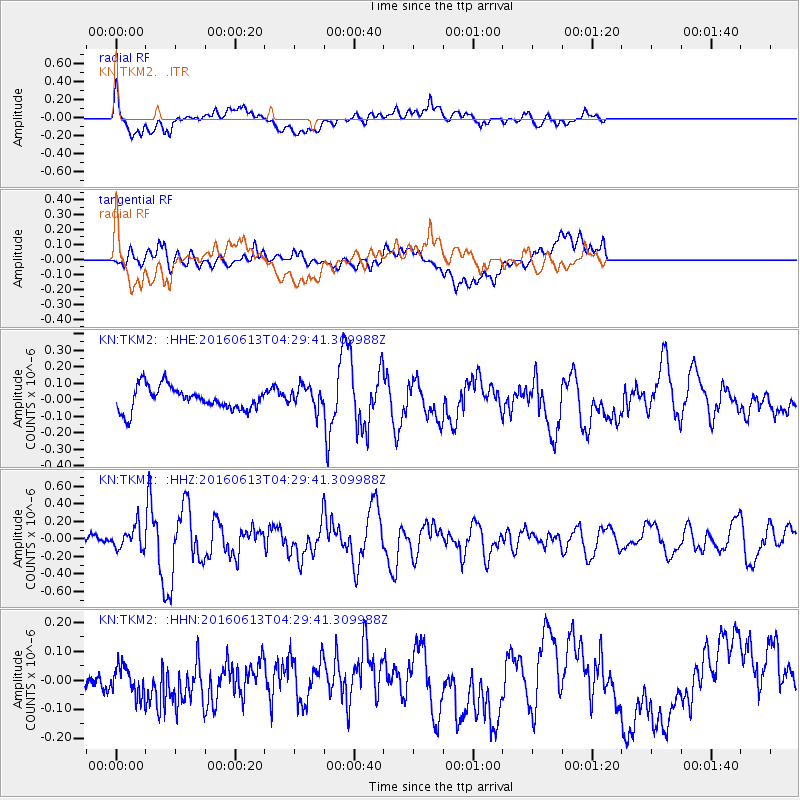
TKM2 - - Earthquake Result Viewer
*The percent match for this event was below the threshold and hence no stack was calculated.
| Earthquake location: |
Ryukyu Islands, Japan |
| Earthquake latitude/longitude: |
27.0/130.2 |
| Earthquake time(UTC): |
2016/06/13 (165) 04:21:43 GMT |
| Earthquake Depth: |
10 km |
| Earthquake Magnitude: |
5.6 MWW, 5.4 MWB, 5.6 MWC |
| Earthquake Catalog/Contributor: |
NEIC PDE/NEIC COMCAT |
|
| Network: |
KN Kyrgyz Seismic Telemetry Network |
| Station: |
TKM2 - |
| Lat/Lon: |
42.92 N/75.60 E |
| Elevation: |
2020 m |
|
| Distance: |
46.7 deg |
| Az: |
304.605 deg |
| Baz: |
91.477 deg |
| Ray Param: |
$rayparam |
*The percent match for this event was below the threshold and hence was not used in the summary stack. |
|
| Radial Match: |
76.54177 % |
| Radial Bump: |
400 |
| Transverse Match: |
49.352356 % |
| Transverse Bump: |
400 |
| SOD ConfigId: |
7422571 |
| Insert Time: |
2019-04-22 20:21:33.872 +0000 |
| GWidth: |
2.5 |
| Max Bumps: |
400 |
| Tol: |
0.001 |
|
Signal To Noise
| Channel | StoN | STA | LTA |
| KN:TKM2: :HHZ:20160613T04:29:41.309988Z | 2.1998417 | 1.3098747E-7 | 5.9544046E-8 |
| KN:TKM2: :HHN:20160613T04:29:41.309988Z | 0.9492991 | 6.620842E-8 | 6.974454E-8 |
| KN:TKM2: :HHE:20160613T04:29:41.309988Z | 0.93484634 | 6.5983635E-8 | 7.058233E-8 |
| Arrivals |
| Ps | |
| PpPs | |
| PsPs/PpSs | |


