You are here: Home > Network List > TA - USArray Transportable Network (new EarthScope stations) Stations List
> Station R11A Troy Canyon, Currant, NV, USA > Earthquake Result Viewer
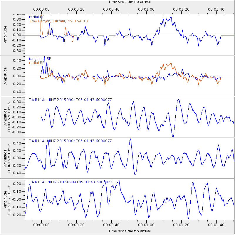
R11A Troy Canyon, Currant, NV, USA - Earthquake Result Viewer
*The percent match for this event was below the threshold and hence no stack was calculated.
| Earthquake location: |
Ryukyu Islands, Japan |
| Earthquake latitude/longitude: |
29.2/130.5 |
| Earthquake time(UTC): |
2015/09/04 (247) 04:49:21 GMT |
| Earthquake Depth: |
10 km |
| Earthquake Magnitude: |
5.5 MB |
| Earthquake Catalog/Contributor: |
NEIC PDE/NEIC COMCAT |
|
| Network: |
TA USArray Transportable Network (new EarthScope stations) |
| Station: |
R11A Troy Canyon, Currant, NV, USA |
| Lat/Lon: |
38.35 N/115.59 W |
| Elevation: |
1756 m |
|
| Distance: |
88.7 deg |
| Az: |
45.989 deg |
| Baz: |
306.93 deg |
| Ray Param: |
$rayparam |
*The percent match for this event was below the threshold and hence was not used in the summary stack. |
|
| Radial Match: |
50.963657 % |
| Radial Bump: |
400 |
| Transverse Match: |
68.99366 % |
| Transverse Bump: |
400 |
| SOD ConfigId: |
1156111 |
| Insert Time: |
2015-09-18 05:21:21.502 +0000 |
| GWidth: |
2.5 |
| Max Bumps: |
400 |
| Tol: |
0.001 |
|
Signal To Noise
| Channel | StoN | STA | LTA |
| TA:R11A: :BHZ:20150904T05:01:43.600007Z | 1.52118 | 2.6930928E-7 | 1.7703972E-7 |
| TA:R11A: :BHN:20150904T05:01:43.600007Z | 0.63828427 | 8.582025E-8 | 1.3445458E-7 |
| TA:R11A: :BHE:20150904T05:01:43.600007Z | 0.764414 | 8.642781E-8 | 1.1306414E-7 |
| Arrivals |
| Ps | |
| PpPs | |
| PsPs/PpSs | |


