You are here: Home > Network List > US - United States National Seismic Network Stations List
> Station BOZ Bozeman, Montana, USA > Earthquake Result Viewer
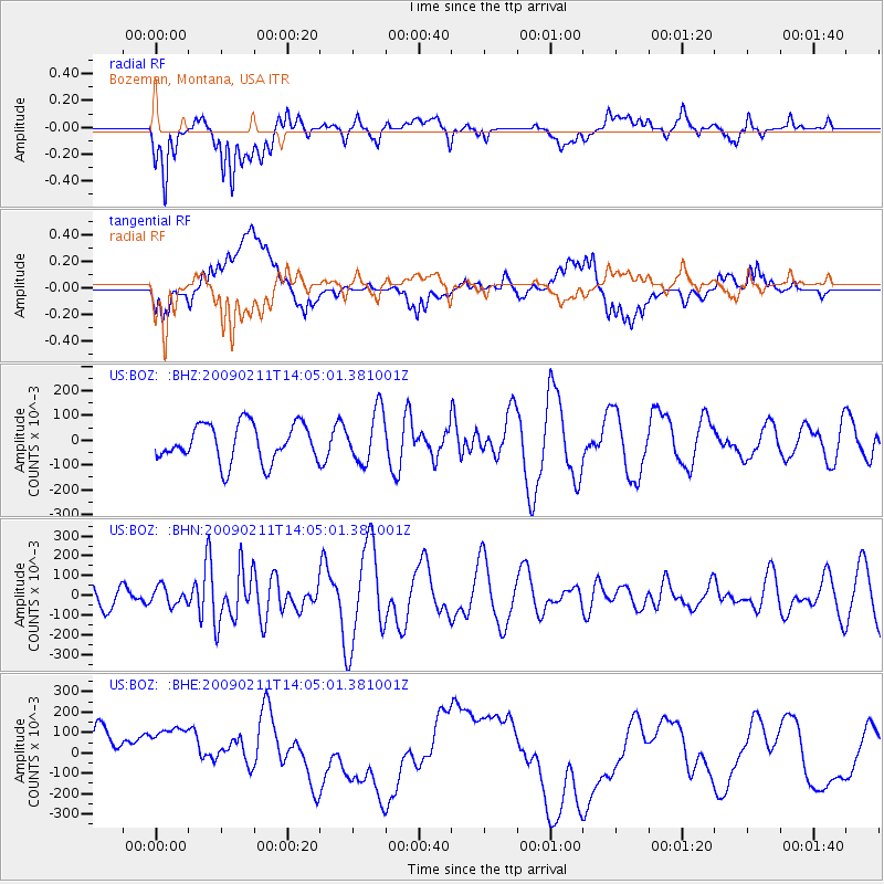
BOZ Bozeman, Montana, USA - Earthquake Result Viewer
*The percent match for this event was below the threshold and hence no stack was calculated.
| Earthquake location: |
Fiji Islands |
| Earthquake latitude/longitude: |
-16.2/178.3 |
| Earthquake time(UTC): |
2009/02/11 (042) 13:52:41 GMT |
| Earthquake Depth: |
10 km |
| Earthquake Magnitude: |
5.6 MB, 5.3 MS, 5.7 MW, 5.7 MW |
| Earthquake Catalog/Contributor: |
WHDF/NEIC |
|
| Network: |
US United States National Seismic Network |
| Station: |
BOZ Bozeman, Montana, USA |
| Lat/Lon: |
45.65 N/111.63 W |
| Elevation: |
1589 m |
|
| Distance: |
88.2 deg |
| Az: |
41.276 deg |
| Baz: |
244.617 deg |
| Ray Param: |
$rayparam |
*The percent match for this event was below the threshold and hence was not used in the summary stack. |
|
| Radial Match: |
42.74573 % |
| Radial Bump: |
400 |
| Transverse Match: |
19.545713 % |
| Transverse Bump: |
400 |
| SOD ConfigId: |
2658 |
| Insert Time: |
2010-03-05 04:36:11.200 +0000 |
| GWidth: |
2.5 |
| Max Bumps: |
400 |
| Tol: |
0.001 |
|
Signal To Noise
| Channel | StoN | STA | LTA |
| US:BOZ: :BHN:20090211T14:05:01.381001Z | 0.50863075 | 0.045076326 | 0.08862289 |
| US:BOZ: :BHE:20090211T14:05:01.381001Z | 1.46472 | 0.21569508 | 0.14726028 |
| US:BOZ: :BHZ:20090211T14:05:01.381001Z | 1.3750834 | 0.104380324 | 0.075908355 |
| Arrivals |
| Ps | |
| PpPs | |
| PsPs/PpSs | |


