You are here: Home > Network List > MM - Myanmar National Seismic Network Stations List
> Station MDY Mandalay, Mandalay, Myanmar > Earthquake Result Viewer
MDY Mandalay, Mandalay, Myanmar - Earthquake Result Viewer
| Earthquake location: |
Vanuatu Islands |
| Earthquake latitude/longitude: |
-18.8/168.8 |
| Earthquake time(UTC): |
2016/06/14 (166) 13:49:22 GMT |
| Earthquake Depth: |
111 km |
| Earthquake Magnitude: |
6.2 MWW, 6.2 MWB |
| Earthquake Catalog/Contributor: |
NEIC PDE/NEIC COMCAT |
|
| Network: |
MM Myanmar National Seismic Network |
| Station: |
MDY Mandalay, Mandalay, Myanmar |
| Lat/Lon: |
22.02 N/96.11 E |
| Elevation: |
97 m |
|
| Distance: |
81.8 deg |
| Az: |
296.48 deg |
| Baz: |
113.946 deg |
| Ray Param: |
0.047063693 |
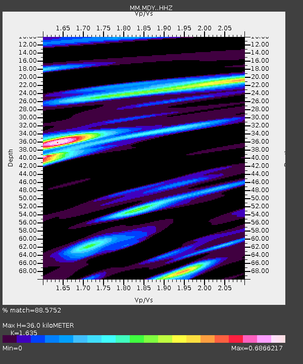
| Estimated Moho Depth: |
36.0 km |
| Estimated Crust Vp/Vs: |
1.63 |
| Assumed Crust Vp: |
6.316 km/s |
| Estimated Crust Vs: |
3.863 km/s |
| Estimated Crust Poisson's Ratio: |
0.20 |
|
| Radial Match: |
88.5752 % |
| Radial Bump: |
361 |
| Transverse Match: |
83.160065 % |
| Transverse Bump: |
400 |
| SOD ConfigId: |
7422571 |
| Insert Time: |
2019-04-22 20:30:57.496 +0000 |
| GWidth: |
2.5 |
| Max Bumps: |
400 |
| Tol: |
0.001 |
|

Signal To Noise
| Channel | StoN | STA | LTA |
| MM:MDY: :HHZ:20160614T14:00:58.358015Z | 11.066878 | 8.9520114E-7 | 8.0890125E-8 |
| MM:MDY: :HHN:20160614T14:00:58.358015Z | 2.0838742 | 1.1052687E-7 | 5.3039127E-8 |
| MM:MDY: :HHE:20160614T14:00:58.358015Z | 6.300419 | 2.7270835E-7 | 4.3284164E-8 |
| Arrivals |
| Ps | 3.7 SECOND |
| PpPs | 15 SECOND |
| PsPs/PpSs | 18 SECOND |


