You are here: Home > Network List > S - Seismographs in Schools Projects Stations List
> Station AUKAT Katherine High School, NT > Earthquake Result Viewer
AUKAT Katherine High School, NT - Earthquake Result Viewer
| Earthquake location: |
Vanuatu Islands |
| Earthquake latitude/longitude: |
-18.8/168.8 |
| Earthquake time(UTC): |
2016/06/14 (166) 13:49:22 GMT |
| Earthquake Depth: |
111 km |
| Earthquake Magnitude: |
6.2 MWW, 6.2 MWB |
| Earthquake Catalog/Contributor: |
NEIC PDE/NEIC COMCAT |
|
| Network: |
S Seismographs in Schools Projects |
| Station: |
AUKAT Katherine High School, NT |
| Lat/Lon: |
14.46 S/132.28 E |
| Elevation: |
122 m |
|
| Distance: |
35.2 deg |
| Az: |
271.37 deg |
| Baz: |
102.096 deg |
| Ray Param: |
0.07696823 |
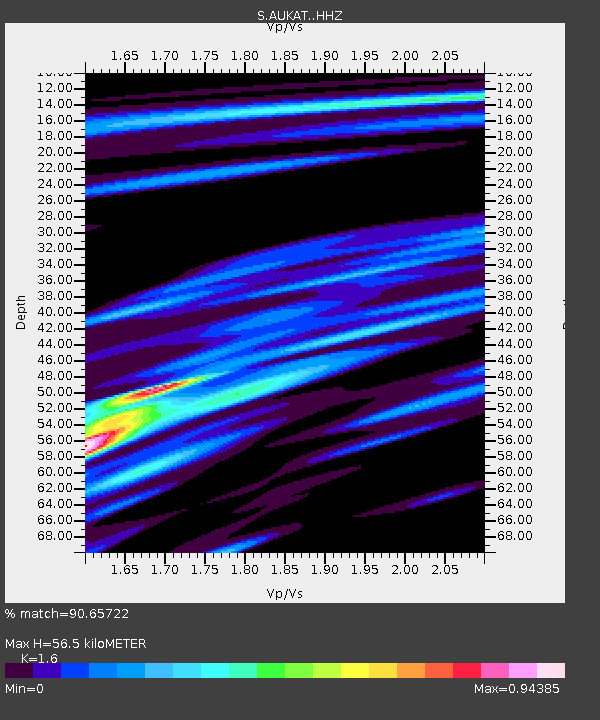
| Estimated Moho Depth: |
56.5 km |
| Estimated Crust Vp/Vs: |
1.60 |
| Assumed Crust Vp: |
6.61 km/s |
| Estimated Crust Vs: |
4.131 km/s |
| Estimated Crust Poisson's Ratio: |
0.18 |
|
| Radial Match: |
90.65722 % |
| Radial Bump: |
400 |
| Transverse Match: |
72.23691 % |
| Transverse Bump: |
400 |
| SOD ConfigId: |
7422571 |
| Insert Time: |
2019-04-22 20:32:03.419 +0000 |
| GWidth: |
2.5 |
| Max Bumps: |
400 |
| Tol: |
0.001 |
|

Signal To Noise
| Channel | StoN | STA | LTA |
| S:AUKAT: :HHZ:20160614T13:55:36.109999Z | 25.13067 | 5.400689E-6 | 2.1490429E-7 |
| S:AUKAT: :HHN:20160614T13:55:36.109999Z | 6.633149 | 1.6625678E-6 | 2.5064531E-7 |
| S:AUKAT: :HHE:20160614T13:55:36.109999Z | 7.373912 | 3.3304495E-6 | 4.5165302E-7 |
| Arrivals |
| Ps | 5.6 SECOND |
| PpPs | 20 SECOND |
| PsPs/PpSs | 26 SECOND |


