You are here: Home > Network List > TA - USArray Transportable Network (new EarthScope stations) Stations List
> Station M20K Styx River, AK, USA > Earthquake Result Viewer
M20K Styx River, AK, USA - Earthquake Result Viewer
| Earthquake location: |
Vanuatu Islands |
| Earthquake latitude/longitude: |
-18.8/168.8 |
| Earthquake time(UTC): |
2016/06/14 (166) 13:49:22 GMT |
| Earthquake Depth: |
111 km |
| Earthquake Magnitude: |
6.2 MWW, 6.2 MWB |
| Earthquake Catalog/Contributor: |
NEIC PDE/NEIC COMCAT |
|
| Network: |
TA USArray Transportable Network (new EarthScope stations) |
| Station: |
M20K Styx River, AK, USA |
| Lat/Lon: |
61.88 N/153.13 W |
| Elevation: |
1107 m |
|
| Distance: |
85.9 deg |
| Az: |
17.022 deg |
| Baz: |
215.837 deg |
| Ray Param: |
0.044211663 |
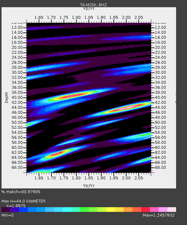
| Estimated Moho Depth: |
44.0 km |
| Estimated Crust Vp/Vs: |
2.00 |
| Assumed Crust Vp: |
6.566 km/s |
| Estimated Crust Vs: |
3.287 km/s |
| Estimated Crust Poisson's Ratio: |
0.33 |
|
| Radial Match: |
80.97985 % |
| Radial Bump: |
400 |
| Transverse Match: |
78.77455 % |
| Transverse Bump: |
342 |
| SOD ConfigId: |
7422571 |
| Insert Time: |
2019-04-22 20:32:31.771 +0000 |
| GWidth: |
2.5 |
| Max Bumps: |
400 |
| Tol: |
0.001 |
|

Signal To Noise
| Channel | StoN | STA | LTA |
| TA:M20K: :BHZ:20160614T14:01:18.824995Z | 3.22455 | 2.2459176E-7 | 6.965057E-8 |
| TA:M20K: :BHN:20160614T14:01:18.824995Z | 1.1853787 | 9.85788E-8 | 8.3162284E-8 |
| TA:M20K: :BHE:20160614T14:01:18.824995Z | 0.89450467 | 8.437899E-8 | 9.43304E-8 |
| Arrivals |
| Ps | 6.8 SECOND |
| PpPs | 20 SECOND |
| PsPs/PpSs | 26 SECOND |


