You are here: Home > Network List > TA - USArray Transportable Network (new EarthScope stations) Stations List
> Station O17K Koliganek, Bristol Bay, AK, USA > Earthquake Result Viewer
O17K Koliganek, Bristol Bay, AK, USA - Earthquake Result Viewer
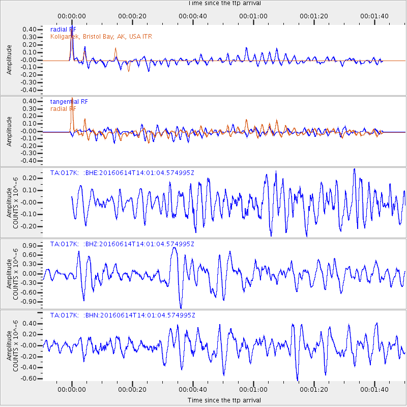
| Earthquake location: |
Vanuatu Islands |
| Earthquake latitude/longitude: |
-18.8/168.8 |
| Earthquake time(UTC): |
2016/06/14 (166) 13:49:22 GMT |
| Earthquake Depth: |
111 km |
| Earthquake Magnitude: |
6.2 MWW, 6.2 MWB |
| Earthquake Catalog/Contributor: |
NEIC PDE/NEIC COMCAT |
|
| Network: |
TA USArray Transportable Network (new EarthScope stations) |
| Station: |
O17K Koliganek, Bristol Bay, AK, USA |
| Lat/Lon: |
59.77 N/157.09 W |
| Elevation: |
156 m |
|
| Distance: |
83.0 deg |
| Az: |
16.598 deg |
| Baz: |
212.34 deg |
| Ray Param: |
0.046222318 |
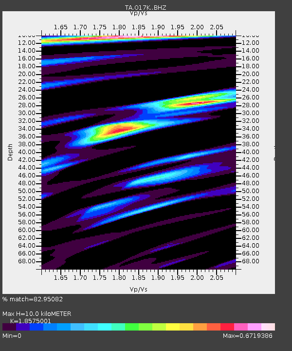
| Estimated Moho Depth: |
10.0 km |
| Estimated Crust Vp/Vs: |
1.86 |
| Assumed Crust Vp: |
6.276 km/s |
| Estimated Crust Vs: |
3.379 km/s |
| Estimated Crust Poisson's Ratio: |
0.30 |
|
| Radial Match: |
82.95082 % |
| Radial Bump: |
380 |
| Transverse Match: |
71.22853 % |
| Transverse Bump: |
400 |
| SOD ConfigId: |
7422571 |
| Insert Time: |
2019-04-22 20:32:39.819 +0000 |
| GWidth: |
2.5 |
| Max Bumps: |
400 |
| Tol: |
0.001 |
|
Signal To Noise
| Channel | StoN | STA | LTA |
| TA:O17K: :BHZ:20160614T14:01:04.574995Z | 4.385874 | 3.798478E-7 | 8.66071E-8 |
| TA:O17K: :BHN:20160614T14:01:04.574995Z | 1.488615 | 1.1041874E-7 | 7.417548E-8 |
| TA:O17K: :BHE:20160614T14:01:04.574995Z | 1.1292479 | 8.782359E-8 | 7.777175E-8 |
| Arrivals |
| Ps | 1.4 SECOND |
| PpPs | 4.4 SECOND |
| PsPs/PpSs | 5.8 SECOND |


