You are here: Home > Network List > UW - Pacific Northwest Regional Seismic Network Stations List
> Station HOOD Mt Hood Meadows, OR CREST BB SMO > Earthquake Result Viewer
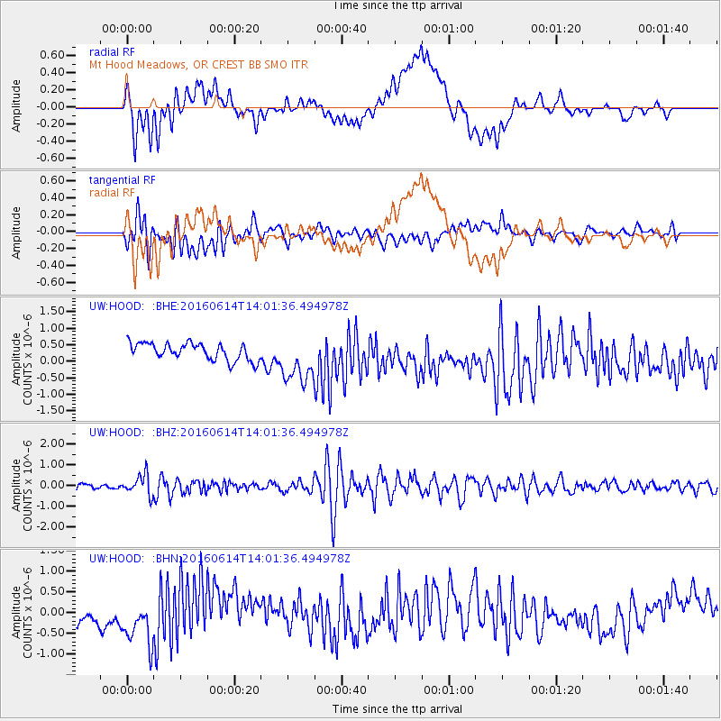
HOOD Mt Hood Meadows, OR CREST BB SMO - Earthquake Result Viewer
*The percent match for this event was below the threshold and hence no stack was calculated.
| Earthquake location: |
Vanuatu Islands |
| Earthquake latitude/longitude: |
-18.8/168.8 |
| Earthquake time(UTC): |
2016/06/14 (166) 13:49:22 GMT |
| Earthquake Depth: |
111 km |
| Earthquake Magnitude: |
6.2 MWW, 6.2 MWB |
| Earthquake Catalog/Contributor: |
NEIC PDE/NEIC COMCAT |
|
| Network: |
UW Pacific Northwest Regional Seismic Network |
| Station: |
HOOD Mt Hood Meadows, OR CREST BB SMO |
| Lat/Lon: |
45.32 N/121.65 W |
| Elevation: |
1520 m |
|
| Distance: |
89.6 deg |
| Az: |
41.374 deg |
| Baz: |
242.58 deg |
| Ray Param: |
$rayparam |
*The percent match for this event was below the threshold and hence was not used in the summary stack. |
|
| Radial Match: |
54.760563 % |
| Radial Bump: |
400 |
| Transverse Match: |
55.00853 % |
| Transverse Bump: |
400 |
| SOD ConfigId: |
7422571 |
| Insert Time: |
2019-04-22 20:33:16.278 +0000 |
| GWidth: |
2.5 |
| Max Bumps: |
400 |
| Tol: |
0.001 |
|
Signal To Noise
| Channel | StoN | STA | LTA |
| UW:HOOD: :BHZ:20160614T14:01:36.494978Z | 3.7254696 | 4.982869E-7 | 1.3375143E-7 |
| UW:HOOD: :BHN:20160614T14:01:36.494978Z | 1.6718439 | 5.444612E-7 | 3.256651E-7 |
| UW:HOOD: :BHE:20160614T14:01:36.494978Z | 2.903372 | 7.4802193E-7 | 2.5763902E-7 |
| Arrivals |
| Ps | |
| PpPs | |
| PsPs/PpSs | |


