You are here: Home > Network List > YT07 - POLENET Stations List
> Station WAWA WAWA > Earthquake Result Viewer
WAWA WAWA - Earthquake Result Viewer
| Earthquake location: |
Vanuatu Islands |
| Earthquake latitude/longitude: |
-18.8/168.8 |
| Earthquake time(UTC): |
2016/06/14 (166) 13:49:22 GMT |
| Earthquake Depth: |
111 km |
| Earthquake Magnitude: |
6.2 MWW, 6.2 MWB |
| Earthquake Catalog/Contributor: |
NEIC PDE/NEIC COMCAT |
|
| Network: |
YT POLENET |
| Station: |
WAWA WAWA |
| Lat/Lon: |
81.58 S/28.42 W |
| Elevation: |
1202 m |
|
| Distance: |
79.5 deg |
| Az: |
177.453 deg |
| Baz: |
196.596 deg |
| Ray Param: |
0.048692048 |
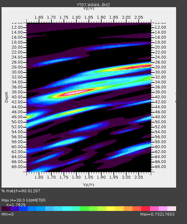
| Estimated Moho Depth: |
38.0 km |
| Estimated Crust Vp/Vs: |
1.79 |
| Assumed Crust Vp: |
6.424 km/s |
| Estimated Crust Vs: |
3.584 km/s |
| Estimated Crust Poisson's Ratio: |
0.27 |
|
| Radial Match: |
90.81287 % |
| Radial Bump: |
400 |
| Transverse Match: |
84.64077 % |
| Transverse Bump: |
400 |
| SOD ConfigId: |
7422571 |
| Insert Time: |
2019-04-22 20:35:12.356 +0000 |
| GWidth: |
2.5 |
| Max Bumps: |
400 |
| Tol: |
0.001 |
|

Signal To Noise
| Channel | StoN | STA | LTA |
| YT:WAWA: :BHZ:20160614T14:00:45.824019Z | 17.683493 | 2.8691975E-6 | 1.6225287E-7 |
| YT:WAWA: :BHN:20160614T14:00:45.824019Z | 7.771934 | 1.1721838E-6 | 1.5082267E-7 |
| YT:WAWA: :BHE:20160614T14:00:45.824019Z | 3.6176705 | 5.104383E-7 | 1.4109585E-7 |
| Arrivals |
| Ps | 4.8 SECOND |
| PpPs | 16 SECOND |
| PsPs/PpSs | 21 SECOND |


