You are here: Home > Network List > CI - Caltech Regional Seismic Network Stations List
> Station SMM Simmler, CA, USA > Earthquake Result Viewer
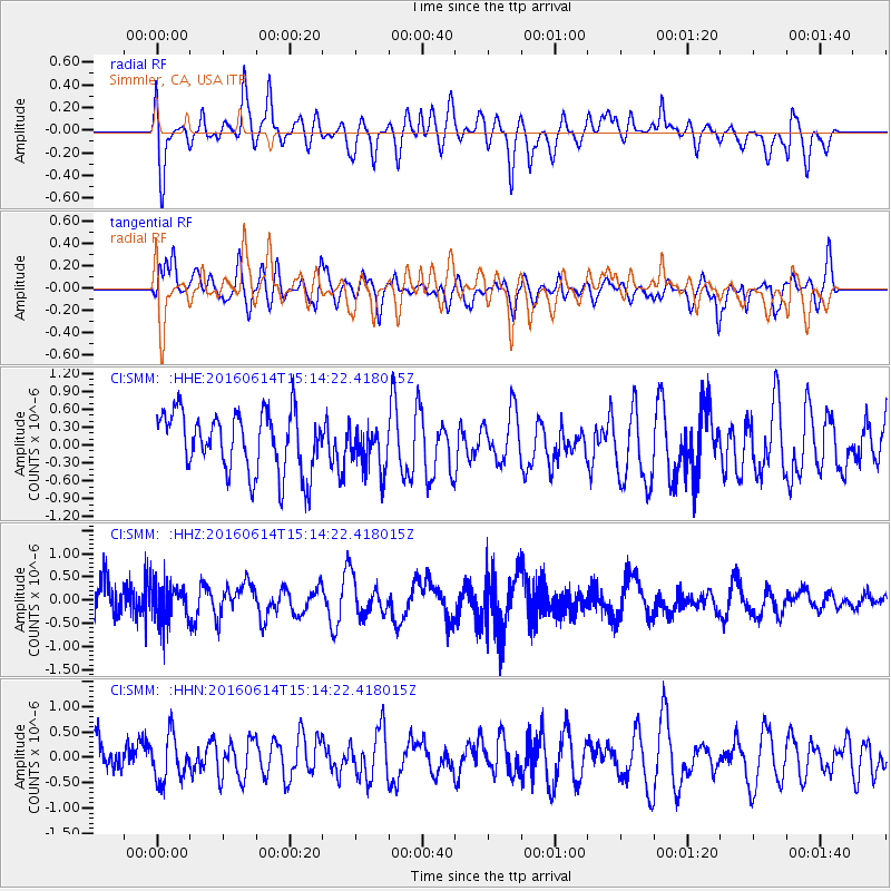
SMM Simmler, CA, USA - Earthquake Result Viewer
*The percent match for this event was below the threshold and hence no stack was calculated.
| Earthquake location: |
Southeast Of Ryukyu Islands |
| Earthquake latitude/longitude: |
26.9/130.2 |
| Earthquake time(UTC): |
2016/06/14 (166) 15:01:56 GMT |
| Earthquake Depth: |
6.0 km |
| Earthquake Magnitude: |
5.6 MWW |
| Earthquake Catalog/Contributor: |
NEIC PDE/NEIC COMCAT |
|
| Network: |
CI Caltech Regional Seismic Network |
| Station: |
SMM Simmler, CA, USA |
| Lat/Lon: |
35.31 N/120.00 W |
| Elevation: |
599 m |
|
| Distance: |
89.3 deg |
| Az: |
50.304 deg |
| Baz: |
302.877 deg |
| Ray Param: |
$rayparam |
*The percent match for this event was below the threshold and hence was not used in the summary stack. |
|
| Radial Match: |
59.92637 % |
| Radial Bump: |
400 |
| Transverse Match: |
54.470238 % |
| Transverse Bump: |
400 |
| SOD ConfigId: |
7422571 |
| Insert Time: |
2019-04-22 20:37:42.514 +0000 |
| GWidth: |
2.5 |
| Max Bumps: |
400 |
| Tol: |
0.001 |
|
Signal To Noise
| Channel | StoN | STA | LTA |
| CI:SMM: :HHZ:20160614T15:14:22.418015Z | 1.1204585 | 4.1484245E-7 | 3.7024347E-7 |
| CI:SMM: :HHN:20160614T15:14:22.418015Z | 1.0033926 | 4.4657662E-7 | 4.450667E-7 |
| CI:SMM: :HHE:20160614T15:14:22.418015Z | 0.7353679 | 3.6764382E-7 | 4.9994543E-7 |
| Arrivals |
| Ps | |
| PpPs | |
| PsPs/PpSs | |


