You are here: Home > Network List > US - United States National Seismic Network Stations List
> Station BOZ Bozeman, Montana, USA > Earthquake Result Viewer
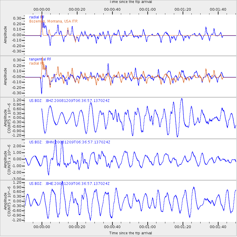
BOZ Bozeman, Montana, USA - Earthquake Result Viewer
*The percent match for this event was below the threshold and hence no stack was calculated.
| Earthquake location: |
Kermadec Islands Region |
| Earthquake latitude/longitude: |
-31.2/-176.9 |
| Earthquake time(UTC): |
2008/12/09 (344) 06:23:59 GMT |
| Earthquake Depth: |
18 km |
| Earthquake Magnitude: |
6.2 MB, 6.7 MS, 6.8 MW, 6.7 MW |
| Earthquake Catalog/Contributor: |
WHDF/NEIC |
|
| Network: |
US United States National Seismic Network |
| Station: |
BOZ Bozeman, Montana, USA |
| Lat/Lon: |
45.65 N/111.63 W |
| Elevation: |
1589 m |
|
| Distance: |
96.7 deg |
| Az: |
39.914 deg |
| Baz: |
231.586 deg |
| Ray Param: |
$rayparam |
*The percent match for this event was below the threshold and hence was not used in the summary stack. |
|
| Radial Match: |
52.937183 % |
| Radial Bump: |
400 |
| Transverse Match: |
63.052124 % |
| Transverse Bump: |
367 |
| SOD ConfigId: |
2658 |
| Insert Time: |
2010-03-05 04:37:46.513 +0000 |
| GWidth: |
2.5 |
| Max Bumps: |
400 |
| Tol: |
0.001 |
|
Signal To Noise
| Channel | StoN | STA | LTA |
| US:BOZ: :BHN:20081209T06:36:57.137024Z | 2.9152398 | 9.80389E-7 | 3.362979E-7 |
| US:BOZ: :BHE:20081209T06:36:57.137024Z | 1.8384745 | 5.4273596E-7 | 2.9520993E-7 |
| US:BOZ: :BHZ:20081209T06:36:57.137024Z | 1.2127441 | 5.331338E-7 | 4.396095E-7 |
| Arrivals |
| Ps | |
| PpPs | |
| PsPs/PpSs | |


