You are here: Home > Network List > KN - Kyrgyz Seismic Telemetry Network Stations List
> Station CHM KN.CHM > Earthquake Result Viewer
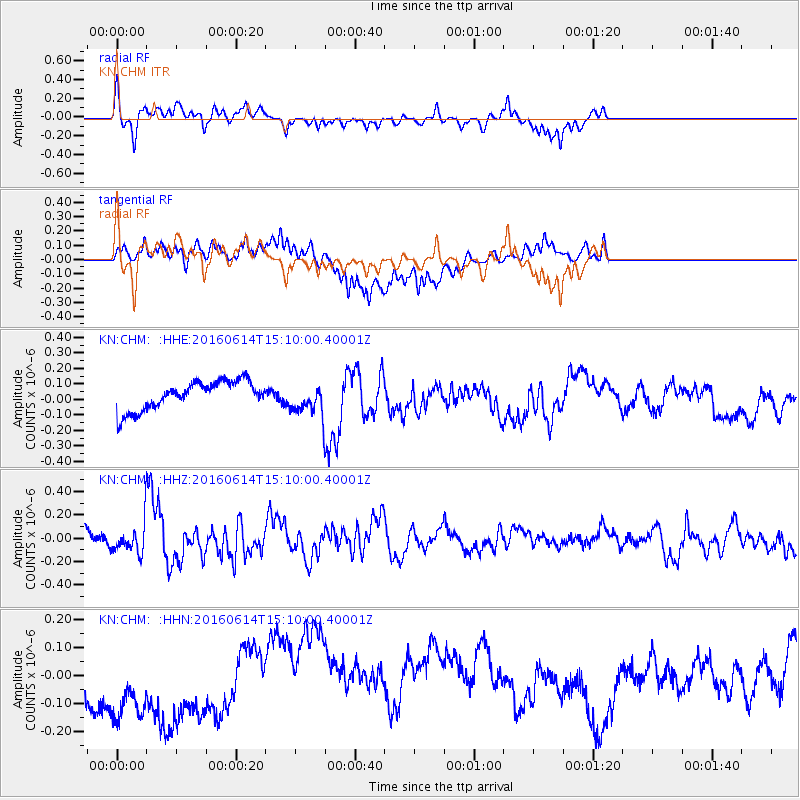
CHM KN.CHM - Earthquake Result Viewer
*The percent match for this event was below the threshold and hence no stack was calculated.
| Earthquake location: |
Southeast Of Ryukyu Islands |
| Earthquake latitude/longitude: |
26.9/130.2 |
| Earthquake time(UTC): |
2016/06/14 (166) 15:01:56 GMT |
| Earthquake Depth: |
6.0 km |
| Earthquake Magnitude: |
5.6 MWW |
| Earthquake Catalog/Contributor: |
NEIC PDE/NEIC COMCAT |
|
| Network: |
KN Kyrgyz Seismic Telemetry Network |
| Station: |
CHM KN.CHM |
| Lat/Lon: |
43.00 N/74.75 E |
| Elevation: |
655 m |
|
| Distance: |
47.3 deg |
| Az: |
304.74 deg |
| Baz: |
91.046 deg |
| Ray Param: |
$rayparam |
*The percent match for this event was below the threshold and hence was not used in the summary stack. |
|
| Radial Match: |
29.527954 % |
| Radial Bump: |
247 |
| Transverse Match: |
53.953655 % |
| Transverse Bump: |
351 |
| SOD ConfigId: |
7422571 |
| Insert Time: |
2019-04-22 20:39:01.603 +0000 |
| GWidth: |
2.5 |
| Max Bumps: |
400 |
| Tol: |
0.001 |
|
Signal To Noise
| Channel | StoN | STA | LTA |
| KN:CHM: :HHZ:20160614T15:10:00.40001Z | 1.3671967 | 1.12928255E-7 | 8.25984E-8 |
| KN:CHM: :HHN:20160614T15:10:00.40001Z | 2.3827007 | 2.0467178E-7 | 8.589908E-8 |
| KN:CHM: :HHE:20160614T15:10:00.40001Z | 0.9840364 | 9.1565695E-8 | 9.305113E-8 |
| Arrivals |
| Ps | |
| PpPs | |
| PsPs/PpSs | |


