You are here: Home > Network List > TA - USArray Transportable Network (new EarthScope stations) Stations List
> Station J20K Nowitna River, AK, USA > Earthquake Result Viewer
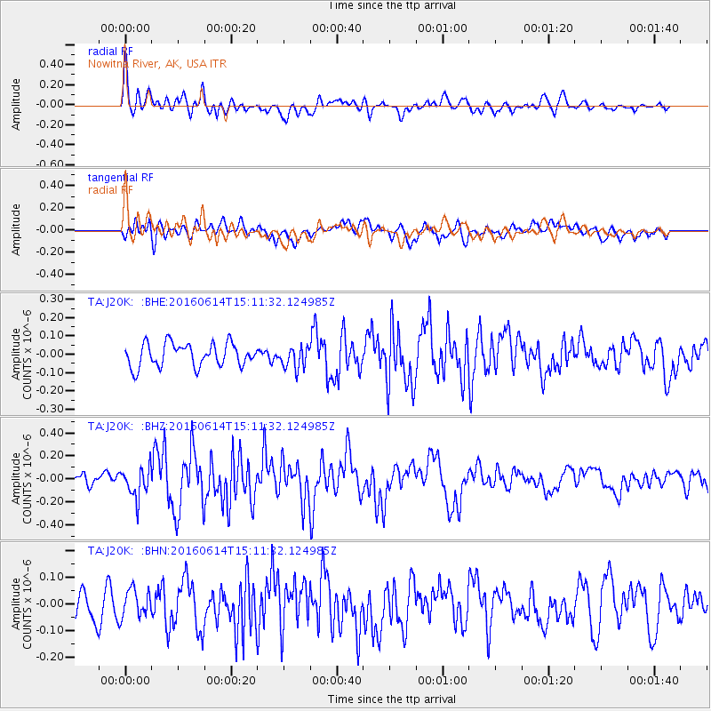
J20K Nowitna River, AK, USA - Earthquake Result Viewer
*The percent match for this event was below the threshold and hence no stack was calculated.
| Earthquake location: |
Southeast Of Ryukyu Islands |
| Earthquake latitude/longitude: |
26.9/130.2 |
| Earthquake time(UTC): |
2016/06/14 (166) 15:01:56 GMT |
| Earthquake Depth: |
6.0 km |
| Earthquake Magnitude: |
5.6 MWW |
| Earthquake Catalog/Contributor: |
NEIC PDE/NEIC COMCAT |
|
| Network: |
TA USArray Transportable Network (new EarthScope stations) |
| Station: |
J20K Nowitna River, AK, USA |
| Lat/Lon: |
64.18 N/154.15 W |
| Elevation: |
314 m |
|
| Distance: |
59.9 deg |
| Az: |
29.383 deg |
| Baz: |
269.917 deg |
| Ray Param: |
$rayparam |
*The percent match for this event was below the threshold and hence was not used in the summary stack. |
|
| Radial Match: |
68.38897 % |
| Radial Bump: |
400 |
| Transverse Match: |
56.40212 % |
| Transverse Bump: |
400 |
| SOD ConfigId: |
7422571 |
| Insert Time: |
2019-04-22 20:40:41.336 +0000 |
| GWidth: |
2.5 |
| Max Bumps: |
400 |
| Tol: |
0.001 |
|
Signal To Noise
| Channel | StoN | STA | LTA |
| TA:J20K: :BHZ:20160614T15:11:32.124985Z | 2.0096073 | 1.3208172E-7 | 6.5725146E-8 |
| TA:J20K: :BHN:20160614T15:11:32.124985Z | 0.7502402 | 4.9859125E-8 | 6.645755E-8 |
| TA:J20K: :BHE:20160614T15:11:32.124985Z | 0.9527729 | 6.01623E-8 | 6.314443E-8 |
| Arrivals |
| Ps | |
| PpPs | |
| PsPs/PpSs | |


