You are here: Home > Network List > US - United States National Seismic Network Stations List
> Station HAWA Hanford, Washington, USA > Earthquake Result Viewer
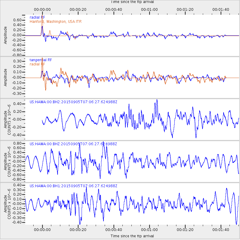
HAWA Hanford, Washington, USA - Earthquake Result Viewer
*The percent match for this event was below the threshold and hence no stack was calculated.
| Earthquake location: |
Andreanof Islands, Aleutian Is. |
| Earthquake latitude/longitude: |
51.4/-174.4 |
| Earthquake time(UTC): |
2015/09/05 (248) 07:00:00 GMT |
| Earthquake Depth: |
12 km |
| Earthquake Magnitude: |
5.6 MB, 4.9 ML, 5.1 MI |
| Earthquake Catalog/Contributor: |
NEIC PDE/NEIC COMCAT |
|
| Network: |
US United States National Seismic Network |
| Station: |
HAWA Hanford, Washington, USA |
| Lat/Lon: |
46.39 N/119.53 W |
| Elevation: |
364 m |
|
| Distance: |
35.7 deg |
| Az: |
75.972 deg |
| Baz: |
298.586 deg |
| Ray Param: |
$rayparam |
*The percent match for this event was below the threshold and hence was not used in the summary stack. |
|
| Radial Match: |
60.533226 % |
| Radial Bump: |
400 |
| Transverse Match: |
57.375313 % |
| Transverse Bump: |
400 |
| SOD ConfigId: |
1156111 |
| Insert Time: |
2015-09-19 07:09:24.945 +0000 |
| GWidth: |
2.5 |
| Max Bumps: |
400 |
| Tol: |
0.001 |
|
Signal To Noise
| Channel | StoN | STA | LTA |
| US:HAWA:00:BHZ:20150905T07:06:27.624988Z | 1.9916795 | 3.1654477E-7 | 1.5893359E-7 |
| US:HAWA:00:BH1:20150905T07:06:27.624988Z | 0.5008276 | 5.4550483E-8 | 1.0892067E-7 |
| US:HAWA:00:BH2:20150905T07:06:27.624988Z | 0.74625397 | 8.451045E-8 | 1.1324623E-7 |
| Arrivals |
| Ps | |
| PpPs | |
| PsPs/PpSs | |


