You are here: Home > Network List > TA - USArray Transportable Network (new EarthScope stations) Stations List
> Station O17K Koliganek, Bristol Bay, AK, USA > Earthquake Result Viewer
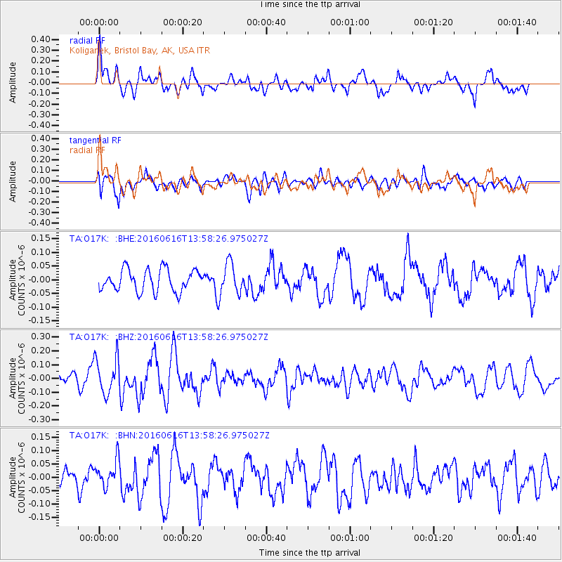
O17K Koliganek, Bristol Bay, AK, USA - Earthquake Result Viewer
*The percent match for this event was below the threshold and hence no stack was calculated.
| Earthquake location: |
Loyalty Islands |
| Earthquake latitude/longitude: |
-20.6/168.9 |
| Earthquake time(UTC): |
2016/06/16 (168) 13:46:24 GMT |
| Earthquake Depth: |
10 km |
| Earthquake Magnitude: |
5.6 MWC, 5.6 MWC |
| Earthquake Catalog/Contributor: |
NEIC PDE/NEIC COMCAT |
|
| Network: |
TA USArray Transportable Network (new EarthScope stations) |
| Station: |
O17K Koliganek, Bristol Bay, AK, USA |
| Lat/Lon: |
59.77 N/157.09 W |
| Elevation: |
156 m |
|
| Distance: |
84.7 deg |
| Az: |
16.499 deg |
| Baz: |
211.73 deg |
| Ray Param: |
$rayparam |
*The percent match for this event was below the threshold and hence was not used in the summary stack. |
|
| Radial Match: |
52.142273 % |
| Radial Bump: |
400 |
| Transverse Match: |
61.393177 % |
| Transverse Bump: |
400 |
| SOD ConfigId: |
7422571 |
| Insert Time: |
2019-04-22 20:49:01.157 +0000 |
| GWidth: |
2.5 |
| Max Bumps: |
400 |
| Tol: |
0.001 |
|
Signal To Noise
| Channel | StoN | STA | LTA |
| TA:O17K: :BHZ:20160616T13:58:26.975027Z | 2.0973692 | 1.2844548E-7 | 6.124124E-8 |
| TA:O17K: :BHN:20160616T13:58:26.975027Z | 1.5306671 | 5.023699E-8 | 3.2820324E-8 |
| TA:O17K: :BHE:20160616T13:58:26.975027Z | 1.3405224 | 5.351611E-8 | 3.9921833E-8 |
| Arrivals |
| Ps | |
| PpPs | |
| PsPs/PpSs | |


