You are here: Home > Network List > TA - USArray Transportable Network (new EarthScope stations) Stations List
> Station O18K Koktuh Hills, AK, USA > Earthquake Result Viewer
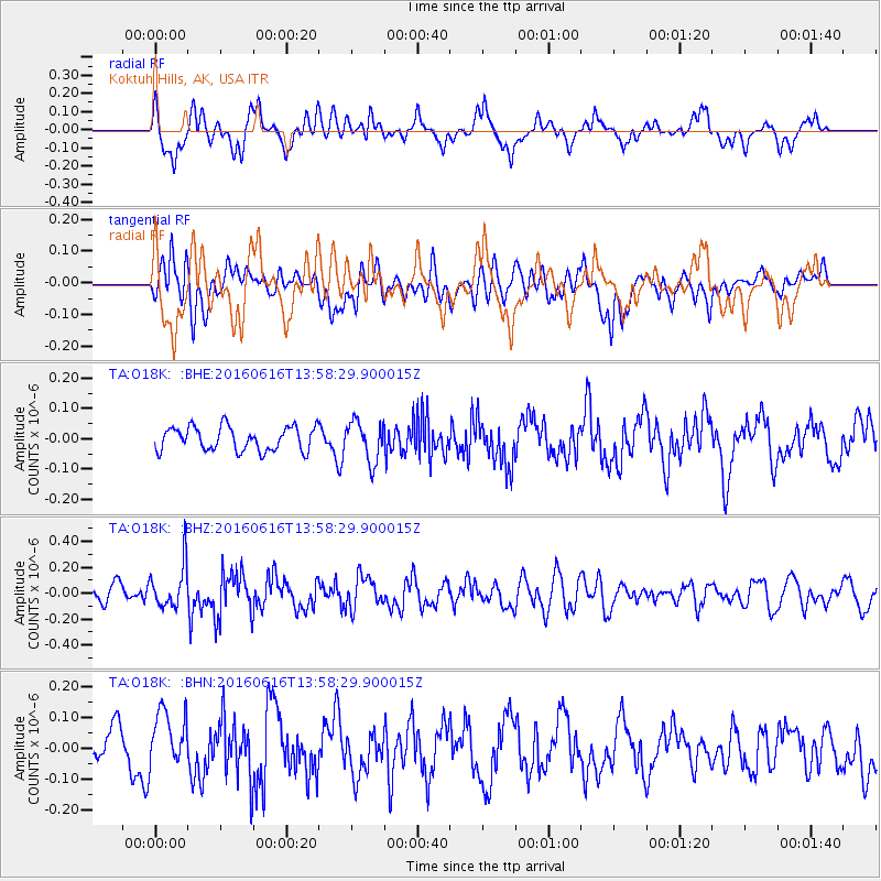
O18K Koktuh Hills, AK, USA - Earthquake Result Viewer
*The percent match for this event was below the threshold and hence no stack was calculated.
| Earthquake location: |
Loyalty Islands |
| Earthquake latitude/longitude: |
-20.6/168.9 |
| Earthquake time(UTC): |
2016/06/16 (168) 13:46:24 GMT |
| Earthquake Depth: |
10 km |
| Earthquake Magnitude: |
5.6 MWC, 5.6 MWC |
| Earthquake Catalog/Contributor: |
NEIC PDE/NEIC COMCAT |
|
| Network: |
TA USArray Transportable Network (new EarthScope stations) |
| Station: |
O18K Koktuh Hills, AK, USA |
| Lat/Lon: |
59.85 N/155.21 W |
| Elevation: |
544 m |
|
| Distance: |
85.3 deg |
| Az: |
17.261 deg |
| Baz: |
213.424 deg |
| Ray Param: |
$rayparam |
*The percent match for this event was below the threshold and hence was not used in the summary stack. |
|
| Radial Match: |
69.642975 % |
| Radial Bump: |
400 |
| Transverse Match: |
60.80742 % |
| Transverse Bump: |
400 |
| SOD ConfigId: |
7422571 |
| Insert Time: |
2019-04-22 20:49:01.337 +0000 |
| GWidth: |
2.5 |
| Max Bumps: |
400 |
| Tol: |
0.001 |
|
Signal To Noise
| Channel | StoN | STA | LTA |
| TA:O18K: :BHZ:20160616T13:58:29.900015Z | 2.6755369 | 1.6709997E-7 | 6.245474E-8 |
| TA:O18K: :BHN:20160616T13:58:29.900015Z | 1.1553231 | 9.257639E-8 | 8.01303E-8 |
| TA:O18K: :BHE:20160616T13:58:29.900015Z | 1.6925837 | 6.655594E-8 | 3.93221E-8 |
| Arrivals |
| Ps | |
| PpPs | |
| PsPs/PpSs | |


