You are here: Home > Network List > TA - USArray Transportable Network (new EarthScope stations) Stations List
> Station P17K Kvichak River, AK, USA > Earthquake Result Viewer
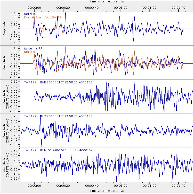
P17K Kvichak River, AK, USA - Earthquake Result Viewer
*The percent match for this event was below the threshold and hence no stack was calculated.
| Earthquake location: |
Loyalty Islands |
| Earthquake latitude/longitude: |
-20.6/168.9 |
| Earthquake time(UTC): |
2016/06/16 (168) 13:46:24 GMT |
| Earthquake Depth: |
10 km |
| Earthquake Magnitude: |
5.6 MWC, 5.6 MWC |
| Earthquake Catalog/Contributor: |
NEIC PDE/NEIC COMCAT |
|
| Network: |
TA USArray Transportable Network (new EarthScope stations) |
| Station: |
P17K Kvichak River, AK, USA |
| Lat/Lon: |
59.20 N/156.44 W |
| Elevation: |
91 m |
|
| Distance: |
84.4 deg |
| Az: |
17.092 deg |
| Baz: |
212.35 deg |
| Ray Param: |
$rayparam |
*The percent match for this event was below the threshold and hence was not used in the summary stack. |
|
| Radial Match: |
66.80037 % |
| Radial Bump: |
400 |
| Transverse Match: |
70.30613 % |
| Transverse Bump: |
400 |
| SOD ConfigId: |
7422571 |
| Insert Time: |
2019-04-22 20:49:04.450 +0000 |
| GWidth: |
2.5 |
| Max Bumps: |
400 |
| Tol: |
0.001 |
|
Signal To Noise
| Channel | StoN | STA | LTA |
| TA:P17K: :BHZ:20160616T13:58:25.400015Z | 3.6316166 | 2.448533E-7 | 6.7422675E-8 |
| TA:P17K: :BHN:20160616T13:58:25.400015Z | 1.0791699 | 1.1275931E-7 | 1.04487086E-7 |
| TA:P17K: :BHE:20160616T13:58:25.400015Z | 1.6056784 | 1.218235E-7 | 7.587042E-8 |
| Arrivals |
| Ps | |
| PpPs | |
| PsPs/PpSs | |


