You are here: Home > Network List > TA - USArray Transportable Network (new EarthScope stations) Stations List
> Station G03D McMinnville, OR, USA > Earthquake Result Viewer
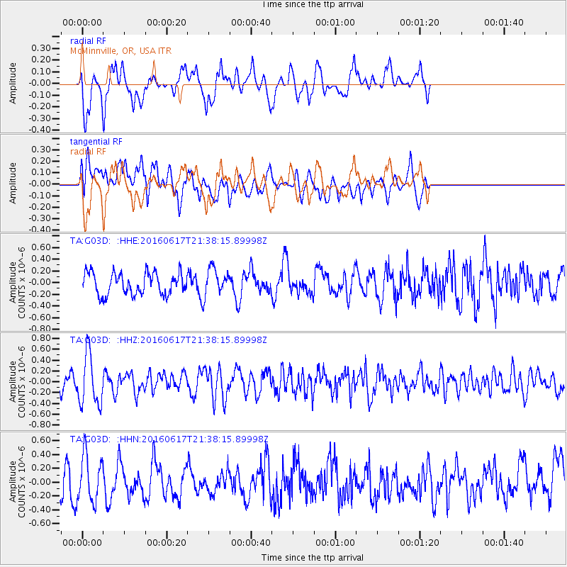
G03D McMinnville, OR, USA - Earthquake Result Viewer
*The percent match for this event was below the threshold and hence no stack was calculated.
| Earthquake location: |
Santa Cruz Islands |
| Earthquake latitude/longitude: |
-11.6/166.3 |
| Earthquake time(UTC): |
2016/06/17 (169) 21:26:17 GMT |
| Earthquake Depth: |
43 km |
| Earthquake Magnitude: |
5.7 MWC, 5.7 MWC |
| Earthquake Catalog/Contributor: |
NEIC PDE/NEIC COMCAT |
|
| Network: |
TA USArray Transportable Network (new EarthScope stations) |
| Station: |
G03D McMinnville, OR, USA |
| Lat/Lon: |
45.21 N/123.26 W |
| Elevation: |
222 m |
|
| Distance: |
84.8 deg |
| Az: |
41.965 deg |
| Baz: |
247.955 deg |
| Ray Param: |
$rayparam |
*The percent match for this event was below the threshold and hence was not used in the summary stack. |
|
| Radial Match: |
64.99407 % |
| Radial Bump: |
400 |
| Transverse Match: |
63.375904 % |
| Transverse Bump: |
400 |
| SOD ConfigId: |
7422571 |
| Insert Time: |
2019-04-22 20:55:25.797 +0000 |
| GWidth: |
2.5 |
| Max Bumps: |
400 |
| Tol: |
0.001 |
|
Signal To Noise
| Channel | StoN | STA | LTA |
| TA:G03D: :HHZ:20160617T21:38:15.89998Z | 2.6300738 | 4.7298408E-7 | 1.7983682E-7 |
| TA:G03D: :HHN:20160617T21:38:15.89998Z | 1.6544182 | 3.316648E-7 | 2.0047217E-7 |
| TA:G03D: :HHE:20160617T21:38:15.89998Z | 1.1174874 | 2.0606356E-7 | 1.84399E-7 |
| Arrivals |
| Ps | |
| PpPs | |
| PsPs/PpSs | |


