You are here: Home > Network List > US - United States National Seismic Network Stations List
> Station HWUT Hardware Ranch, Cache County, Utah, USA > Earthquake Result Viewer
HWUT Hardware Ranch, Cache County, Utah, USA - Earthquake Result Viewer
| Earthquake location: |
El Salvador |
| Earthquake latitude/longitude: |
13.0/-88.7 |
| Earthquake time(UTC): |
2001/01/13 (013) 17:33:32 GMT |
| Earthquake Depth: |
60 km |
| Earthquake Magnitude: |
6.4 MB, 7.8 MS, 7.7 MW, 7.5 ME |
| Earthquake Catalog/Contributor: |
WHDF/NEIC |
|
| Network: |
US United States National Seismic Network |
| Station: |
HWUT Hardware Ranch, Cache County, Utah, USA |
| Lat/Lon: |
41.61 N/111.57 W |
| Elevation: |
1830 m |
|
| Distance: |
34.8 deg |
| Az: |
329.203 deg |
| Baz: |
138.292 deg |
| Ray Param: |
0.07741898 |
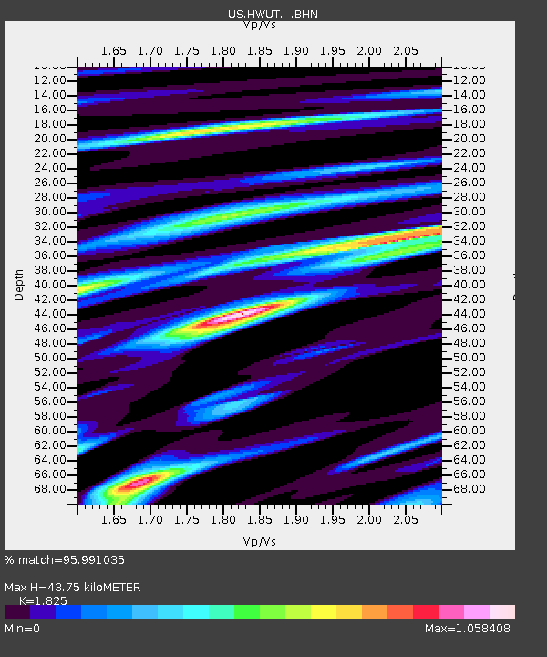
| Estimated Moho Depth: |
43.75 km |
| Estimated Crust Vp/Vs: |
1.83 |
| Assumed Crust Vp: |
6.155 km/s |
| Estimated Crust Vs: |
3.373 km/s |
| Estimated Crust Poisson's Ratio: |
0.29 |
|
| Radial Match: |
95.991035 % |
| Radial Bump: |
318 |
| Transverse Match: |
72.61523 % |
| Transverse Bump: |
400 |
| SOD ConfigId: |
110165 |
| Insert Time: |
2010-03-05 04:39:05.493 +0000 |
| GWidth: |
2.5 |
| Max Bumps: |
400 |
| Tol: |
0.001 |
|

Signal To Noise
| Channel | StoN | STA | LTA |
| US:HWUT: :BHN:20010113T17:39:46.623011Z | 3.156623 | 1.2102313E-6 | 3.8339434E-7 |
| US:HWUT: :BHE:20010113T17:39:46.623011Z | 2.3724751 | 1.1715118E-6 | 4.937931E-7 |
| US:HWUT: :BHZ:20010113T17:39:46.610011Z | 8.276606 | 3.198877E-6 | 3.8649625E-7 |
| Arrivals |
| Ps | 6.3 SECOND |
| PpPs | 19 SECOND |
| PsPs/PpSs | 25 SECOND |


