You are here: Home > Network List > US - United States National Seismic Network Stations List
> Station HWUT Hardware Ranch, Cache County, Utah, USA > Earthquake Result Viewer
HWUT Hardware Ranch, Cache County, Utah, USA - Earthquake Result Viewer
| Earthquake location: |
Near Coast Of Northern Chile |
| Earthquake latitude/longitude: |
-27.5/-70.6 |
| Earthquake time(UTC): |
2002/04/18 (108) 16:08:36 GMT |
| Earthquake Depth: |
62 km |
| Earthquake Magnitude: |
6.2 MB, 6.7 MW, 6.6 MW |
| Earthquake Catalog/Contributor: |
WHDF/NEIC |
|
| Network: |
US United States National Seismic Network |
| Station: |
HWUT Hardware Ranch, Cache County, Utah, USA |
| Lat/Lon: |
41.61 N/111.57 W |
| Elevation: |
1830 m |
|
| Distance: |
78.5 deg |
| Az: |
329.882 deg |
| Baz: |
143.547 deg |
| Ray Param: |
0.04944431 |
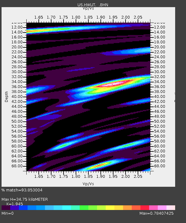
| Estimated Moho Depth: |
34.75 km |
| Estimated Crust Vp/Vs: |
1.95 |
| Assumed Crust Vp: |
6.155 km/s |
| Estimated Crust Vs: |
3.164 km/s |
| Estimated Crust Poisson's Ratio: |
0.32 |
|
| Radial Match: |
93.853004 % |
| Radial Bump: |
400 |
| Transverse Match: |
93.87475 % |
| Transverse Bump: |
400 |
| SOD ConfigId: |
110177 |
| Insert Time: |
2010-03-05 04:39:18.747 +0000 |
| GWidth: |
2.5 |
| Max Bumps: |
400 |
| Tol: |
0.001 |
|

Signal To Noise
| Channel | StoN | STA | LTA |
| US:HWUT: :BHN:20020418T16:20:00.527009Z | 0.95694846 | 2.3736522E-9 | 2.4804387E-9 |
| US:HWUT: :BHE:20020418T16:20:00.527009Z | 3.4848876 | 4.0837796E-7 | 1.1718541E-7 |
| US:HWUT: :BHZ:20020418T16:20:00.527009Z | 26.780445 | 1.9138827E-6 | 7.1465685E-8 |
| Arrivals |
| Ps | 5.5 SECOND |
| PpPs | 16 SECOND |
| PsPs/PpSs | 22 SECOND |


