You are here: Home > Network List > US - United States National Seismic Network Stations List
> Station HWUT Hardware Ranch, Cache County, Utah, USA > Earthquake Result Viewer
HWUT Hardware Ranch, Cache County, Utah, USA - Earthquake Result Viewer
| Earthquake location: |
E. Russia-N.E. China Border Reg. |
| Earthquake latitude/longitude: |
43.8/130.7 |
| Earthquake time(UTC): |
2002/06/28 (179) 17:19:30 GMT |
| Earthquake Depth: |
566 km |
| Earthquake Magnitude: |
6.7 MB, 7.3 MW, 7.3 MW |
| Earthquake Catalog/Contributor: |
WHDF/NEIC |
|
| Network: |
US United States National Seismic Network |
| Station: |
HWUT Hardware Ranch, Cache County, Utah, USA |
| Lat/Lon: |
41.61 N/111.57 W |
| Elevation: |
1830 m |
|
| Distance: |
78.3 deg |
| Az: |
42.658 deg |
| Baz: |
319.096 deg |
| Ray Param: |
0.04798382 |
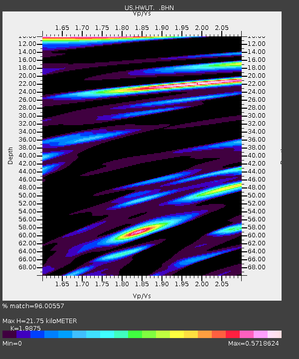
| Estimated Moho Depth: |
21.75 km |
| Estimated Crust Vp/Vs: |
1.99 |
| Assumed Crust Vp: |
6.155 km/s |
| Estimated Crust Vs: |
3.097 km/s |
| Estimated Crust Poisson's Ratio: |
0.33 |
|
| Radial Match: |
96.00557 % |
| Radial Bump: |
400 |
| Transverse Match: |
95.966736 % |
| Transverse Bump: |
400 |
| SOD ConfigId: |
110177 |
| Insert Time: |
2010-03-05 04:39:26.185 +0000 |
| GWidth: |
2.5 |
| Max Bumps: |
400 |
| Tol: |
0.001 |
|

Signal To Noise
| Channel | StoN | STA | LTA |
| US:HWUT: :BHN:20020628T17:30:01.202007Z | 0.764073 | 3.2341627E-9 | 4.232793E-9 |
| US:HWUT: :BHE:20020628T17:30:01.202007Z | 16.737011 | 1.0920364E-6 | 6.52468E-8 |
| US:HWUT: :BHZ:20020628T17:30:01.202007Z | 77.29501 | 7.2635426E-6 | 9.3971686E-8 |
| Arrivals |
| Ps | 3.6 SECOND |
| PpPs | 10 SECOND |
| PsPs/PpSs | 14 SECOND |


